Original Article
, Volume: 6( 1)Room Like Shapes with Free Standing Walls
- *Correspondence:
- Greg Orme, School of Arts and Science, Undergraduate Science Student, University of Queensland, Brisbane, Australia, Tel: 07-33656195; E-mail: Gregory.orme@uqconnect.edu.au
Received: October 21, 2016; Accepted: March 10, 2017; Published: March 19, 2017
Citation: Greg Orme. Room Like Shapes with Free Standing Walls. J Space Explor. 2016;6(1):114.
Abstract
Amazonis Planitia on Mars has many pits of unusual shapes, concentrated in an area west of Olympus Mons. They have approximately the same area, with a similar depth and with the same kinds of walls around their edges. These walls appear to have gaps in them such as where a door or entrance would appear. There are also unusual hills in this area, many appear to be hollow with signs of settling on their exteriors. The proposed hypothesis is that some of these formations are artificial, the hills may have been pingoes that were modified. The pits may have been Kaarst lakes. This area is near the Square Mesa formations, on the other side of the paleosea between Elysium Mons and Olympus Mons. The walls surrounding these pits may have used similar construction methods as the proposed walls around these mesa formations. Their being close to extinct volcanoes may mean they used them as a heat source, to melt the ice and keep this paleosea liquid around them. They may also have created weather patterns with Hadley cells, the heat from the volcanoes may have created a shore breeze. This would have brought in humid air which may then have been circulated outward as rain or snow clouds. Another proposed hypothesis is that these pits were the lower parts of former buildings, some hills nearby may still have these roofs on them. They would perhaps have been mud roofs or materials that could have crumbled into soil filling part of these depressions.
Keywords
Square Mesa; pits; Amazonis Planitia; Acidalia Planitia; Utopia Planitia; lacustrine; paleosea; polar wander; hollow hills
Introduction
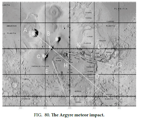
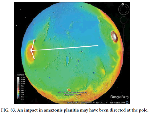
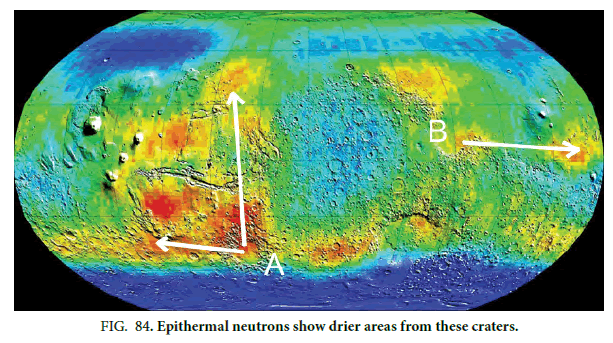
Mars is known to have undergone polar wander in the past. A proposed cause of this polar wander was the Argyre meteor impact [1]. There are two hypotheses proposed that are associated with this impact, one is that it was deliberately caused as part of a terraforming project. This proposed explanation of possible artifacts on Mars is that someone visited Mars around 3.7 Ga, probably with the aim of terraforming it and seeding it with life. They would have done this using oblique meteor impacts directing shock waves at the poles. This would melt the ice at the poles creating seas, also increasing the air pressure by sublimating frozen gases at the poles. Additionally, volcanic outgassing created by these impacts would have thickened the atmosphere. The second proposed hypothesis is that this impact, or several impacts, happened by chance. Then life may have evolved indigenously, reaching a high enough level of sentience to create low levels of technology. There is little difference between the two hypotheses other than life on Mars would have been seeded in the first case, and evolved by itself in the second case. Occam’s Razor would suggest that the second hypothesis is more likely as it is simpler.
In both scenarios, whether sentient life was seeded or it evolved on Mars, as the planet cooled this life would have died out hundreds of millions or even billions of years ago. All that remains, according to these hypotheses, that has been found so far are enigmatic formations discovered in images from NASA’s orbital cameras. In both cases the evidence provided is likely to be a tiny fraction of the artifacts on Mars, its surveying is in the very early stages. The proposed hypotheses imply a large civilization existed, perhaps with millions of inhabitants. There is little reason to shy away from this proposed evidence, it is clear from the Rovers and Cameras orbiting Mars that there is no one there now, and perhaps no life remaining at all. If sufficient evidence can be found, then perhaps these areas will be more extensively reimaged to settle the question.
This artificiality hypothesis was first put forward with the discovery of the Cydonia Face by the Viking orbiter, then with the Mars Orbital Camera other possible artifacts such as Nefertiti and the Crowned Face were discovered. More of this is explained in [1]. With an increasing number of these discoveries a more complete model is forming as several interlocking hypotheses. The formations in this paper may falsify the hypothesis of the existence of this larger civilization, these kinds of hills and pits are very common but mainly around a former Martian equator or on the edges of extinct volcanoes. Three of these sites of possible artifacts contain humanoid faces as described in [1], known as the Cydonia Face, Nefertiti, and the Crowned Face. These faces along with other possible artifacts form a great circle like an ancient equator, this corresponds to a pole close to one proposed by Schultz and Lutz-Garitan [2] west of Hellas Crater. This may then help narrow down when these formations were built, if they are artificial. An important part of this model is where these hypothetical creatures lived, and whether there is evidence of buildings. If these formations were buildings, then they imply a large population. If they are natural formations, then the remaining possible artifacts imply a much smaller number of these creatures.
This evidence should be viewed with some caution because of its controversial nature. The main methodology used in falsification, that artificial structures should be different enough from natural ones. This is not a surprising hypothesis, most buildings on Earth can be differentiated from natural geology. These formations are then compared with known geological processes on Mars to show any differences between the two. Many looks artificial, but this line of argument is generally avoided to focus on differentiating them from natural formations. Mars is a large planet, sooner or later artificial looking formations will be found by the sheer number of them. Many can then be a form of pareidolia, but where buildings are imagined to be seen instead of faces.
Natural Explanations, the Null Hypothesis
Jones et al. [3] discuss how a pingo is a perennial frost mound, it has a core of ice formed by an injection of water. It is covered with soil, on Earth or Mars it could also be covered with plants. They form by the injection of water into near-surface permafrost which then freezes. Because ice expands by about 9% in volume this forms an ice core which pushes up the overlying sediments. More water may rise under the pingos and freeze, this can cause them to grow. This can then result in a hill with a similar shape to the formations discussed here. There are hydrostatic (closed-system) and hydraulic (open-system) modes of formation. The hydrostatic pingos tend to form in drained lake basins, this may have been water runoff from Olympus Mons as shown by outflow channels directed at these formations. Hydraulic pingos form in discontinuous permafrost, the water source can be a sub-permafrost aquifer. These pingo types commonly occur in areas with topographic relief, such as lower hillslopes, alluvial fans, and ?uvial valleys.
It is intended here to differentiate these formations from pingos to falsify the null hypothesis, as they are the closest form of natural geological formation to them. However, they would also be ideal to be altered for habitation, they would either have an empty core after the ice melted or this could be drained away by exposing part of it to the atmosphere. Also, a collapsed pingo could be used far more easily than building a habitable enclosure from scratch. It would also explain why these possible buildings are similar to natural formations, the differences between them would mainly be found by looking at parts of their surface. This also gives a way to falsify the artificiality hypothesis, if there are parts of these formations different enough from pingos then that would indicate some parts of them are artificial. With the other possible artifact sites, it makes sense for dwellings to exist, the a priori prediction here is that these hills and pits will appear more artificial when these areas are reimaged by HiRise. So far, they are mainly imaged by CTX which is the low-resolution camera of the HiRise orbiter. Each formation then can be falsified if they appear more natural when reimaged. There are hundreds of these formations so their all appearing artificial by random chance should be very unlikely.
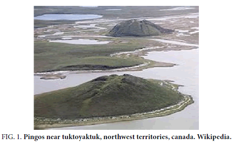
Figure. 1 shows some pingos in Canada, they show a settling on the surface which is similar to some of the Martian formations discussed here. This occurs when the ice core is melting and the sediments above begin to settle downwards. The ice lens inside can ablate or melt, this creates a hollow area that the upper surface can subside into or collapse completely.
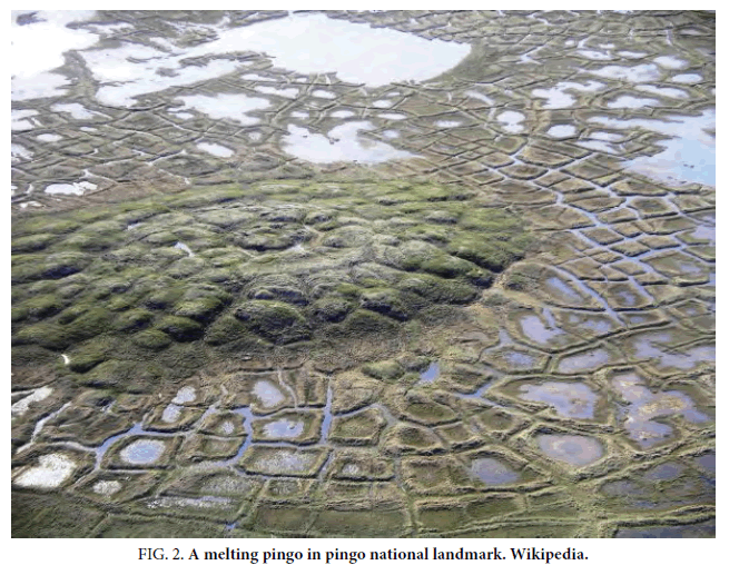
Figure. 2 shows a melting and collapsing pingo, the polygons on its surface are similar to on some of these Martian formations.
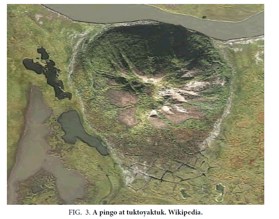
Figure. 3 shows an overhead view of the most distant pingo (Figure. 1).
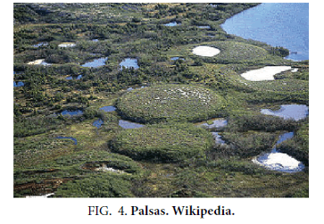
Figure. 4 shows palsas, these are low, often oval, frost heaves occurring in polar and subpolar climates containing permanently frozen ice lenses. Palsas, like pingos, consist of an ice core with overlying soil, they may develop from ground water without additional hydrostatic pressure and so are flatter. Some of the Martian hills discussed here are flatter like this. However, they generally have a highly irregular shape which differentiates them from palsas and pingos.
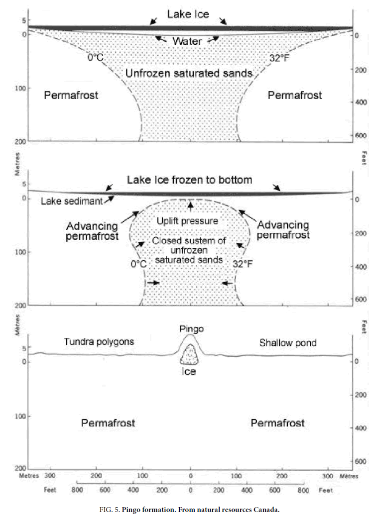
Figure. 5 shows how unfrozen saturated sands can lead to pingo creation, the water rises and freezes. This expands about 9% in volume giving the pingo a dome shape. Because this ice tends to form a rounded shape it is much less likely to have angular corners like many of these Martian formations. Figure. 3 and 4 are both round, it indicates this shape is a property of an ice lens.
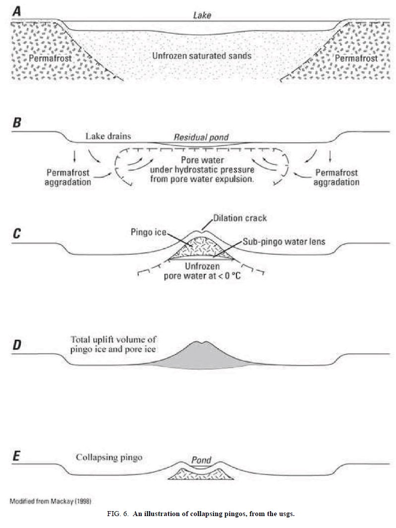
Figure.6 is another example of this, the pingo can collapse forming a pingo scar. The ice lens ablates or melts, the sediments on its surface crumble into the cavity forming a depression with wall like shapes around it. These walls however tend to be rounded in pingos and palsas while the Martian formations are not. This represents a problem for the natural or null hypothesis because the collapse of a pingo should still have the rounded shape as its scar.
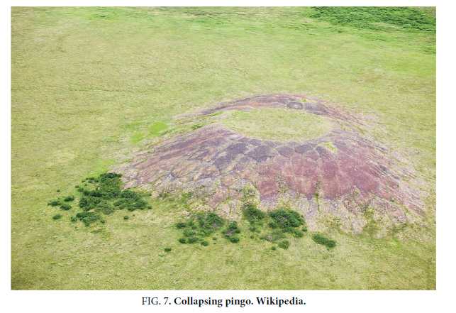
Figure.7 shows a collapsing Earth pingo, sometimes the ice core can become sealed inside and it does not collapse into a scar. The null hypothesis implies some of these Martian formations could retain these ice lenses even now. Polygons are also a common feature of pingos on Earth, however the Martian formations in this area show no polygons but in some cases irregular rock fragments on their surfaces.
Vasil'chuk et al. [4] have an example in their Figure. 2 of a collapsed center of a pingo, similar to some of the Martian formations examined here. They discuss how there are approximately 1600 pingos in Western Siberia, so they can also form in large numbers like these formations. Pingos can be tens of meters high, on Mars they may be higher because of the lower gravity. It is possible then for there to be large numbers of pingos in a small area, like this part of Amazonis Planitia examined here.
Mouginis-Mark and Wilson [5] discuss the Galaxias Quadrangle on Mars, 33.0-35.5° N, 216.0-218.0° W. It is part of the artificiality hypothesis that some areas were habitable because of being near volcanoes, these would have kept some of the paleoseas liquid. A ring of possible settlements around Elysium Mons have been mapped out, many of these have similar structures to these hills and pits. There are so many of these hills and pits a population in the millions of inhabitants was conceivable, the large numbers of these formations make the natural hypothesis more problematic. If there were only a few of these formations, then random deviations might make a natural formation unusual enough to appear artificial. This is the usual objection to the Martian Faces, that random chance will occasionally produce a few realistic faces in clouds on Earth, and in the Martian terrain. However, there are so many of these hills and pits that a random deviation due to chance is not possible. This paper then concentrates on looking at the differences between them and known natural formations, to try to falsify this null hypothesis. Because they are highly eroded they may also tend to become more natural looking over time, particularly if they are modified pingos and palsas originally.
Hrad Vallis [5] could have been covered by an ice sheet, this could have been related to a possible former North Pole in this area [1]. In [1] it was proposed a shallow impact created the Argyre Crater and Tharsis Montes. Because there was a South Pole near Solis Planum, close to where the Tharsis Montes rose, the impact caused the polar ice to melt creating the paleoseas in the Northern Lowlands. Opposite this was the South Pole, antipodal volcanism or a second shallow impact may have caused the rise of the 3 Elysium Highlands volcanoes: Elysium Mons, Hecates Tholus, and Albor Tholus. This ice sheet referred to by [5] may be this former pole. The authors ask where this ice sheet came from, considering this as unknown.
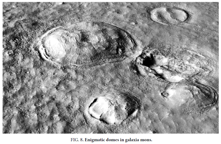
Near Galaxia Mons the authors [5] discuss enigmatic domes (their words) that are 20 m to 25 m high and <1 km in diameter, they are similar to the possibly artificial formations, referred to as hollow hills, discussed in this paper. The authors do not propose any artificial hypothesis, nor do any of the other references in this paper suggest artificial processes. The authors propose these enigmatic domes are pingos and collapsed pingos. These would have collapsed forming pingo scars, they are a similar shape to the pits with surrounding walls discussed in this paper. However, the possibly artificial formations in Amazonis Planitia are much more irregularly shaped than these circular domes (Figure. 8).
These pingos [5] would have collapsed when the ice sheet receded. This might then be either when the polar ice melted with the Argyre impact [1], or when Mars cooled and the ice sublimated to the poles. Figure. 8 shows these domes at 35° 060 N, 142° 310 W, distant from the 3 Elysium Highlands volcanoes but perhaps receiving heated sea or Artesian water from them. With a Northern ocean, there would have been currents as on Earth, these volcanoes would have helped to create these currents and cause heated water to circulate further from them.
This area then may also have been habitable, there are unusual formations in this area similar to the possibly artificial ones discussed in this paper. It may then be another population center according to the artificiality hypothesis. These domes show signs of collapse which can be explained from the loss of the ice core in the pingos. More problematic are the ridges which appear to bisect the pits, these may have been built to support the roofs as these were rebuilt. An ice core should not form a central ridge like this. The ice lens in a pingo forms from freezing water, just as a freezing lake should not form walls in it the ice here should remain a single piece. The authors [5] do not identify the process that formed these domes with any certainty.
Harris and Ross [6] discuss how a pingo on Earth can have a diameter of up to 250 meters, this would be expected to be larger on Mars with lower gravity. They also show a collapsed closed system pingo in their Figure. 2, this can be compared to the possibly artificial walled pits examined in this paper. This example of theirs is much more rounded and circular compared to the Martian formations.
Their Figure.3. shows how pingos can form and collapse into these pingo scars like these walled pits. As their diagram shows, the ice core should tend to form a single piece not be broken up into separate walled segments. The pingos form generally from circular or elliptical taliks of unfrozen water, the formations on Mars are often of very different shapes to Earth taliks. The authors also discuss how pingo degradation is accompanied by the development of radial dilation cracks, this occurs through the bending and extension of the frozen overburden as the pingos grow. These cracks do not appear to occur on these Martian formations, the artificiality hypothesis is that the pingo surfaces have been repaired by mud or cement filling in any cracks. This is a logical solution if the environment was habitable, a large hill with a hollow core would be much easier to patch than building from scratch.
A summit crater can form exposing the ice core and causing it to melt sometimes forming a lake, this can explain some of the deformations on the top of these possibly artificial formations. Thermal erosion of the surrounding frozen ridge causes the lake to expand with intermittent breaching of the central pond, resulting in drainage outflow. There does not appear to be signs of these outflow channels or of lakes forming next to these possibly artificial formations. However north of them there are some similar formations with this ponding, it may be that this area was warmer. These are not examined in this paper. This could be explained by the ice sublimating if the air pressure had fallen below the triple point of water. This is where ice vaporizes into a gas without a liquid phase. However, this area has been proposed to have a long lived paleosea of up to a billion years. Ponding and outflow channels should then have occurred with at least some of these formations if they are natural. Complete thaw of the ice core can leave a pond, similar to the pits described here, surrounded by a ridge of sediment that accumulated around the base of the former pingo from mass movements. The collapse of the pingo could then form these walls around the central pit similar to the formations examined here. Because these pingos are rounded it would be expected the ridge of sediment would also have this rounded shape. However, the Martian formations have wall shapes of even height and width following highly angular and unusual shapes. The material from the collapsed pingo then is not seen, the walls are apparently vertical, it may have been artificially moved or fell into the pingo scar.
Soare et al. [7] discuss how closed-system pingos on Mars would indicate ponded water at these sites, a freeze thaw cycle, and also the temperature and pressure would have to be above the triple point of water. Their Figure. 2h is a good example of a pingo scar with slump material, similar to some of the Martian formations described in this paper. However, these are much less random looking in appearance than the Earth examples.
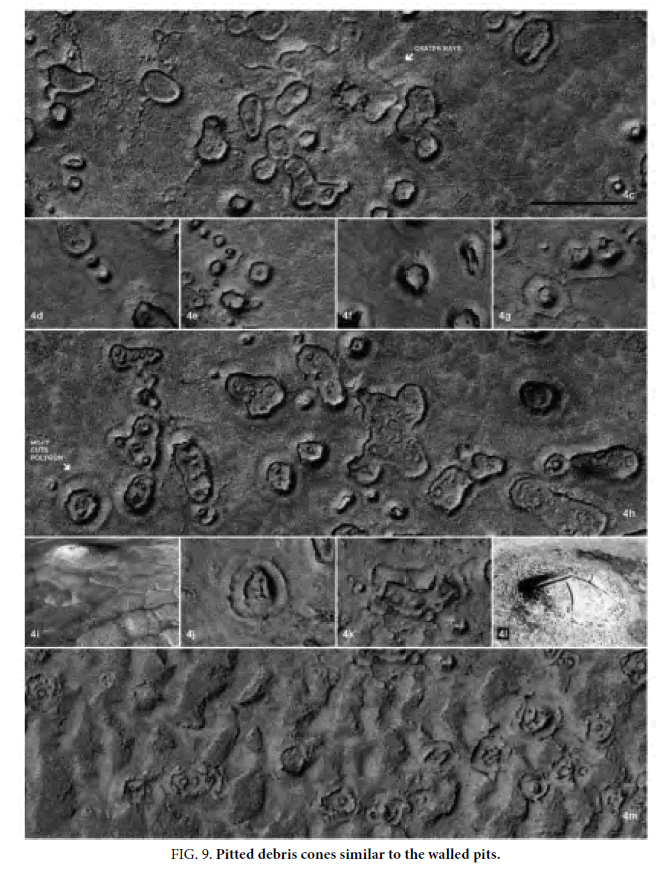
Page and Murray [8] discuss hundreds of pitted debris cones in Elysium Planitia, these are similar to some of the walled pits hypothesized to be artificial. They are presumed to be explosive, forming from an interaction of molten lava with near surface ground ice. This would be a different hypothesis to pingo scars. They also discuss how these would be difficult to distinguish from pingos remotely. Figure.9 shows examples of these, some of the walled shapes appear to go around several cones. This could indicate [8] that some pingos reformed in the debris of older ones. The artificiality hypothesis here would be that these had a roof on them that disappeared over time. 4L (Figure.9) is an example of how this roof may have cracked and disintegrated leaving the walled enclosures. If pingos were close together then they may have been combined artificially into a larger hollow dwelling, in some cases there appears to be corridors connecting the hills shown later.
Page and Murray [8] also suggest that the lava-ice mechanism is just one explanation, that they may also be pingo scars. They say that before pingos rupture they do not have summit depressions, 4I (Figure.9) is an Arctic pingo on Earth. These formations do not have summit craters which makes the volcanic origin less likely. Pingos tend to have cracks that propagate downwards from their summits, as will be seen later these cracks are not found in the possibly artificial structures described here. Some of the shapes can be controlled by polygons as in 4E, giving a 6-sided shape. However, this is not seen around the possibly artificial formations discussed here nor are any polygons visible on the flat ground around them. Some of the pitted cones (Figure.9) are surrounded by depressions as are seen around Earth pingos, this occurs from the episodic growing and melting of the ice cores. When the ice core is uncovered, this leads to the pingo decaying, then the ice is lost by ablation.
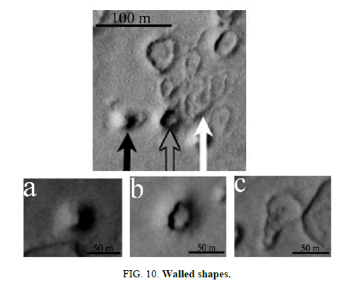
Burr et al. [9] discuss similar formations in Athabasca Vallis, near 10° N, 204° W. They also interpret these formations to come from near-surface ground ice. These are suggested to be pingos, collapsing pingos, pingo scars, and thermal contraction polygons. The ground ice that could have formed the mounds and rimmed features may have come from the deposition of saturated sediment during ?ooding; an alternative is magmatically cycled groundwater. Some pingo ice may still remain inside these features, the authors suggest they may contain evidence of a former biosphere. Figure.10 shows these formations, similar to Figure. 7. B shows a cavity like a degrading pingo, however as will be seen this is different to the possibly artificial formations discussed in this paper. C is problematic in that the wall seems to cross over itself like a piece of string, it is difficult to see how an ice core could create this structure. The surface of a degrading pingo tends to form a depression that may pulsate, eventually this later forms cavities similar to Figure.10. Figure.6 shows the interior ice core of a pingo, being formed from water this should not been forming interior wall shapes. This area may also have artificial formations, it could then be another large-scale settlement but is not examined in this paper.
Possibly Artificial Formations
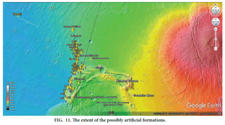
The next section discusses the possibly artificial formations extending from 34° to 43° North and from 141° to 142° West. The previous section will be referred to so as to differentiate these formations from pingos, and to falsify the natural or null hypothesis. This area appears to have received water from Olympus Mons according to the outflow channels there, perhaps this was another source of heat for an inhabited area rather than being on the old Martian equator. They would appear to have been on the edge of the proposed paleosea. Figure.11 shows pins on Google Mars that were selected as unusual formations. This was done without looking at the elevation map, they turned out to be on the edge of this proposed paleosea. It is likely then that these formations, whether artificial or natural, are related to this elevation. The red area to the right is Olympus Mons. The blue color represents an approximate water level, the colors used by NASA however were not intended to define an actual water level but have some relationship to this proposed paleosea. These question marks and other names shown here represent predictions that they will appear more artificial when reimaged by HiRise. Because there are so many predictions the odds of this occurring by chance would be very remote.
Three Rooms
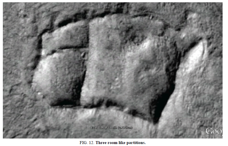
In Figure.12, a house like shape is shown, it has 3 room shapes with each having an entrance at ground level. It has a larger main like entrance on the upper right. This could be used like a dwelling today by putting a dome over the walls. Some of the hills nearby may have retained a mud or cement dome over these kinds of depressions, they are referred to as hollow hills in this artificiality hypothesis. This pit may have been a pingo scar, a modified pingo may have collapsed leaving some of the artificial supports as these walls. These appear different to those shown in Figure.9 and 10, instead of an ice lens forming one rounded shape here it would have to form 3 with almost straight walls between them. Whether this is possible for an ice lens then is an important factor in falsifying the null hypothesis. All the processes show in forming pingos, such as in Figure.5 and 6 have no way of former segmented ice cores like these room shapes. Also, Kaarst lakes do not have any geological process to form segments like this.
If this was a modified pingo scar, the walls would have been artificially reformed on the edges and then the interior walls created. A roof might have been made of vegetation or mud, then have collapsed and disappeared. The processes in Figure.5 and 6 could then have caused the pingo roof to collapse leaving this formation. However, the shape is not rounded at all unlike pingos in general so this shape tends to falsify the null hypothesis.
Many similar walled shapes are in Figure.9; however all appear to be rounded without these straighter sides, and none seem to have these interior wall-like ridges. These walled pits are also not related to typical polygonal shapes, also polygons are cracks while these are ridges. This then tends to falsify the pingo geological explanation. In Figure. 8 the top right formation appears to be a collapsed dome with a similar interior wall like ridge. These may then also have been braced to prevent collapse.Figure. 2 and 3 show Earth pingos, these are developing cracks and polygons prior to collapse. This formation does not connect to other polygons like in Figure.3. If this was formed with polygons, then others outside of the pit would have to disappear by some mechanism. Usually then polygons are connected together, as shown in Figure.9, they are generally 6 sided not this irregular shape.
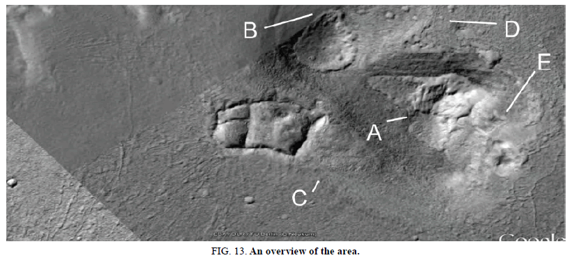
Figure.13shows the house like formation in Figure.12, the hills to its right have unusual summits on highly unusual shapes for pingos. They may then be hollow as buildings that did not collapse. The central part of the hill appears to be a different lighter material, the darker areas around it may have been built up. Alternatively, the summits may have been patched if these were collapsing pingos, the depressions in the summit show no signs of cracks or polygons associated with their deformation. If these are hollow then they are likely to remain intact, if artificial then it may hold clues of this proposed extinct civilization. With many thousands like this on Mars it would take archeologists lifetimes to catalogue them all. They have no real resemblance to Figure. 2,3, 4, and 7.
In the hill to the right some parts seem to have subsided showing a T shaped ridge at A. This is like the interior walls in the depression, it implies they are related formations. This dome then may be in the process of collapsing or has been patched with interior walls. If it is collapsing, then the sediment may eventually degrade and fill up the remaining scar like the 3-roomed depression. For example, if the roof was made of mud, as is used for construction in some parts of Earth, then when it collapsed it could completely disintegrate into soil. When the paleoseas sublimated, and moved to the poles, these roofs might have experienced severe storms that broke them up into mud leaving the walled depressions. The flat floor in these depressions could be from the roof where it dissolved into mud then solidified. These hills are similar to the Earth pingos in Figure.3,4, and 7, but in each case as if the degraded surface was patched. There is an impression of a darker skin that surrounded the summits coming to an unusual point shape at B, this exposes a different lighter material underneath it further towards the summit. C and D also show the unusual shape of the whole formation, the two hills almost form a S shape. The Earth pingo examples have nothing like this difference in albedo, how two dissimilar layers could form like this is unknown and may falsify the null hypothesis. The depressions are quite deep in the roof on the bottom right at E, however this has not left a hole. If the depression is a natural pingo scar, then it is unlikely this hill would have subsided without leaving a cavity. Some of the grooves in the terrain to the left of the walled pit may have been roads, these are examined later.
Two Rooms
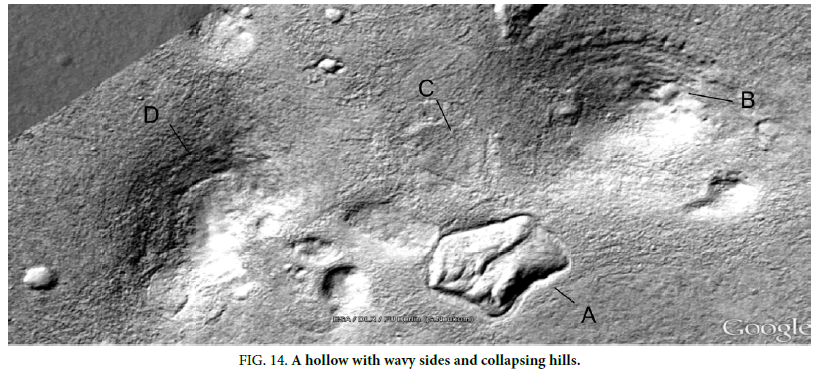
Figure. 14 shows a similar house like shape at A with more wavy sides, these arcs can make walls stronger. There is a central wall to hold up the possible former roof. This appears to be different to a pingo scar because of its unusual shape, the walls are of approximately constant height and width not like debris. The shape is rounded in some parts but is straight on the base, this is not circular like a typical pingo. The central wall is also problematic for how an ice lens would form the shape of the pingo scar.
The other hills at B and D also show ridges along them similar to the ridge in the depression, this could be where subsidence is causing the central walls to become visible. The hill to the upper right has a squarish shape at B on it like walls showing through. It is the most similar to a circular pingo shape such as in Figure. 2 and 3. Just above this depression at C could be another one filled completely with soil, this is also not a natural pingo scar shape. The hill to the left appears to have a curved wall at D showing through on its upper surface.Figure.9 and 10 also showed walled depressions that may be natural, but they are very rounded like an ice lens might be expected to make. The hills B and D have depressions on their surfaces like in the Earth pingo in Figure. 2 , but the settling is not accompanied by visible cracks like it has been patched.
Heart Shaped Depression
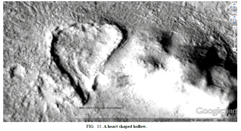
Figure.15 shows a heart shaped formation with the same kind of walls, also with an entrance at the bottom. The hill on the right also shows signs of subsidence like a pingo, but with no cracks and no central area where an ice lens would be degrading. The ground inside this depression appears to be very similar to that outside it, perhaps this was a completely constructed wall rather than a walled depression. This is again very different to the shapes in Figure.9 and 10, the usually rounded ice core is unlikely to form this sharp vertex of the heart shape.
A Single Room
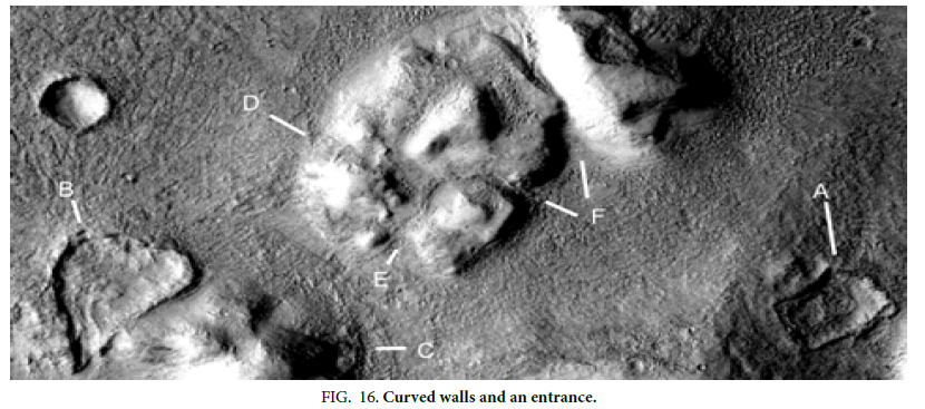
Figure.16 shows another kind of shape with the same walls at A, each wall has about the same height and thickness. The heart shaped depression is at B, the same kind of process such as a growing ice core, would have to create these two different shapes. The hill at C is the one in Figure.15, the other hill has a similar shape but here the depressions appear to have collapsed at D, E, and F. This is then not a pingo as ice cores are rounded and circular not shaped like corridors. It looks then like separate hills were bridged with some kind of covering, such as mud or cement. Some natural process would otherwise have to create these hollow shapes between hills, which appears to be unknown in geology.
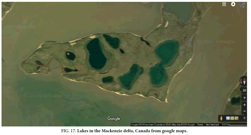
Figure.17 is an example of some Kaarst lakes and pingo scars in the Mackenzie Delta Canada. As shown these can have angular shapes like in Figure.16. Figure.3 and 4 are also surrounded by lakes, these can form from water leaking out of a pingo as it degrades. A lake generally would not have these walls, and a pingo tends to be round not with these angled corners. Some of these depressions could then be lakes, but something then would have to form these regular walls around them. If artificial they may have been designed to hold water, but then the entrances are problematic unless they are from erosion.
Varied Shaped Depressions
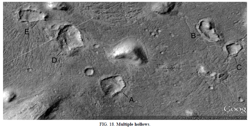
Figure. 18 shows many more like this, different shapes with the same kinds of raised walls. Each is not rounded in shape like a pingo scar. They might be Kaarst lakes or turloughs, but they would be typically formed by springs underneath them filling them with water. If so then how the walls formed around them remains problematic, tending to falsify this natural explanation. These pits usually appear to have an entrance to the structure through a gap in the wall, perhaps there was a gate there and this was to keep some animals inside. This would be a logical reason to build a wall around a pit like this on Earth, lower parts of the enclosure may also have accumulated water. Walls like this have been built around farms and animal enclosures on Earth.
The hill in the bottom left has a wall like ridge on its surface, perhaps showing signs of collapsing. A shows another pit with an entrance, also with regular walls around it. B shows an irregular pit shape with walls, the mound may have been a support for the mud dome. C also has walls and an entrance as do D and E. Figure.6 shows how these should form if they were pingo scars, but again they have straighter sides than the formations in Figure.9 and 10. The hill between B and D has a depression around it similar to that formed by water leaking out of a pingo. There are no visible polygons that would fit into these angular pit shapes. B has a mound inside it similar to proposed pingos Figure. 8, but this is on the edge of the shape. Some of the grooves may have been roads to move between these pits and hills, more examples are shown later.
A Central Mound for Support
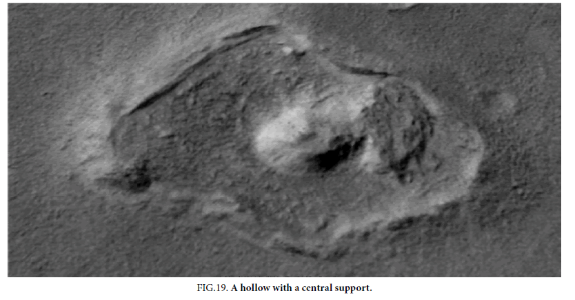
Figure. 19 also has angular shaped walls with an entrance, this is unlike a typical rounded pingo shape. These angled walls could have connected to a pingo domes such as in Figure.2, however the internal shape is not likely to have been an ice lens. The central mound could have been a natural formation that acted as a support for the roof, it could also have been a growing pingo. To the right of this central mound there appears to be an attached part of the former roof. If this was a growing pingo inside an old pingo scar, then it should not have this part of the old pingo roof connected to it.
The depression may be filled to some degree from this roof material, however as with all these depressions there are no signs of large fragments, polygons, such as in Figure.2, or broken supports for a roof. It’s likely then the roof, if there was one, was made of mud or organic materials that could disintegrate. It’s unlikely a roof would have collapsed when there was high wind otherwise there would be a pile of this soil, or dunes, on one side of these depressions. Figure.14 does appear to contain some dunes, these may be from the roof material. If the ocean was sublimating as Mars cooled then this might still have produced a lot of wind and rain with the atmosphere becoming humid, the rain or the humidity itself might then soften the mud roofs. The rain water might have quickly sublimated again, but it should have taken a long time for the triple point of water to have been passed. Extreme weather then was likely at this time. This formation is similar to some in Figure.9, however it is not a regular polygon shape.
Single Wall Supports
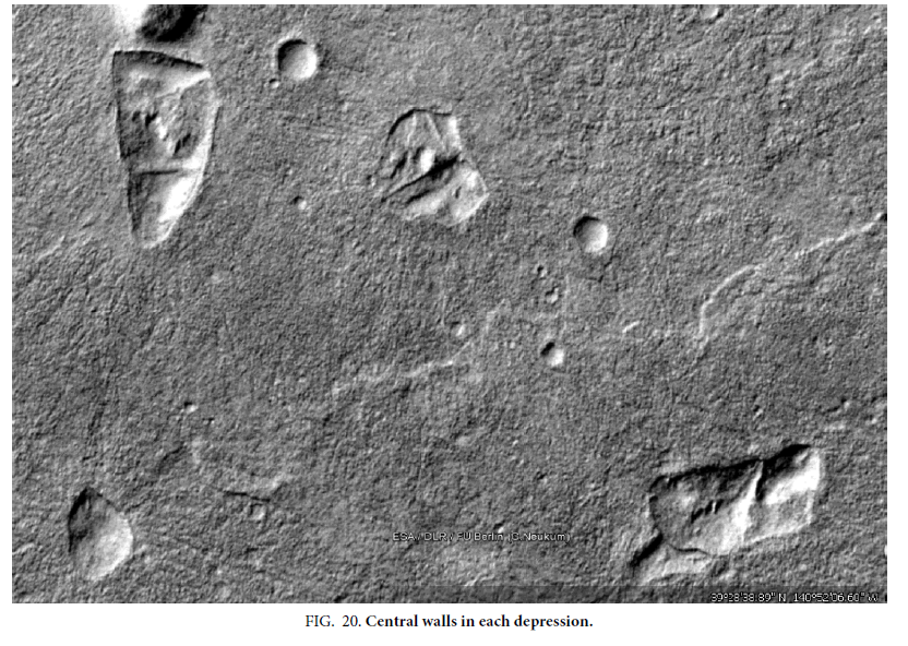
Figure.20 shows 3 more, each with straight walls in them as if to hold up a roof. In this area, virtually every depression has this unusual kind of shape with walls and central supports unlike in pingo scars. If Figure.9were pingos then they would have formed very differently from these. The hills all appear to have the same unusual shapes often with wall like ridges showing on their surfaces. This implies either some unknown geological explanation or artificial modifications to natural formations. Further away from this area there are no depressions like this, and hills revert to normal shapes. Figure. 12 and 14 have pits with similar interior ridges, there is a strong connection between the outline of these pits and the hills nearby. It implies then that the pits formed from some of these hills or vice versa, but these are not typical pingo shapes such as with 3.
A Rectangular Depression
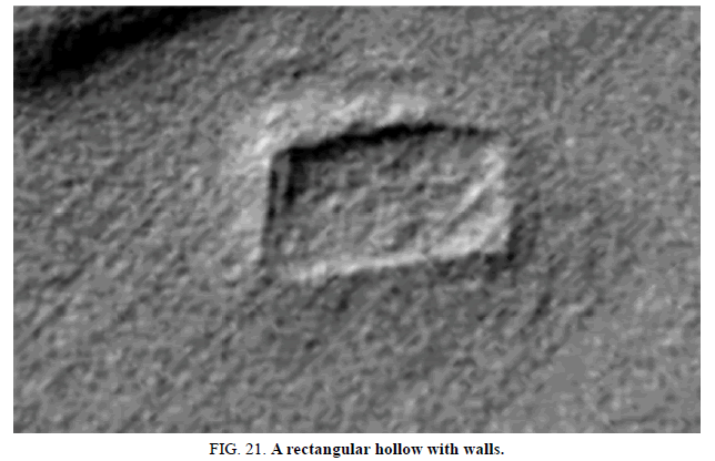
Figure.21 shows a walled depression that is almost rectangular, it may have been a perfect rectangle but was distorted by uneven weathering of the sides. Outside this wall the ground seems to be increasing in elevation as a slope like in Figure. 19, this continued upwards would give a rounded hill shape. It is similar to one of the lakes in Figure.17, however the walls around it imply it is a pingo scar. This is not a polygon shape like some in Figure.9. It may be a pingo was artificially hollowed out inside to a squarish shape, and then it later collapsed to an unusual pingo scar shape.
Layered Terrain
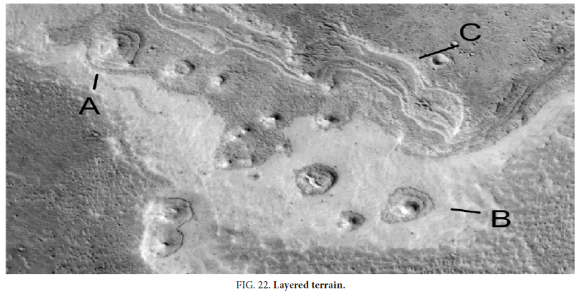
Some of the following formations appear to have layers in them. They can be lower on the edges, rising up in concentric circles to a peak. They can have a central plug similar to the degraded pingo in Figure.2, but instead of polygons they have these layered concentric rounded arcs. If artificial this can be based on arches, the rounded shape could be hollow and supported by circles of bricks like a Corbel Dome shown later in this paper.
Image ESP_012729_1830 Figure.22 shows some hills with layering at A and B, also a layered slope at C. However, the layered hills in this paper have some characteristics inconsistent with layers being deposited as sediments. Some appear on a flat surface, more like the layers inside a tree trunk. Others are lower on the outside, but not in a consistent way due to gravity laying down sediments.
A First Amphitheater Shape and the Rectangular Hollow
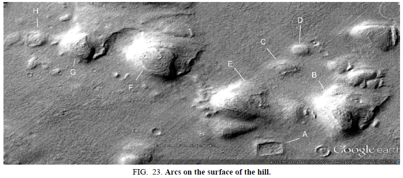
The rectangle (Figure.21) is shown below Figure.23 at the bottom at A, to the north west of this is another hill with circles on its surface at F. This is like a nearby possible artifact referred to as the amphitheater. The circular arcs are reminiscent of seats, this led to the name of an amphitheater, but if artificial they would likely be to strengthen the dome. It is then a friendly name not likely to describe its purpose if artificial, more likely the arcs would be strengthening a hollow area under them. These could then have been collapsing pingos that had their roofs strengthened using arches and domes.
All the hills here have unusual shapes; each could be hollow as described. These circular arcs on the surface could be used for strengthening like with an arch, this could be the typical method of construction which might only show through where an outer skin on the roof is thinning. B shows a plug like shape, as if to seal a depression on the surface like with Figure.3. The plug shape is similar to the center of Figure.2. C is like a pingo with a depressed central section, however this can also be like the skin like outer material peeling away. There are hundreds of examples of this outer skin degrading, usually on the southern side. Sometimes these arcs are exposed, in other cases there is a mottled or fragmented appearance like rock fragments. No signs of polygons like in Figure.2 have been observed so far here.
D then would be like this complete shape, either a natural pingo or one that has been modified. E has some unusual shapes on its lower side, this near vertical edge is harder to explain as a pingo because the ice lens tends to form with shallow sides. G shows another pingo like shape such as in Figure.3, but possibly with the depression sealed with arc like shapes. H shows a rounded depression with a central ridge like the other walled depressions shown here. It is also like the walled pit in Figure.21 but as part of a hill. This supports the hypothesis that these depressions were former hills, but they are not shaped like typical pingo scars.
A Second Amphitheater Shape
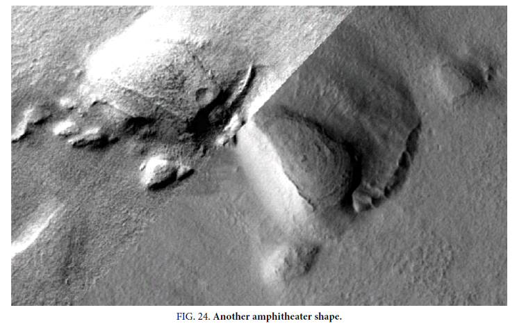
Figure.24 shows another amphitheater shape with circular arcs on its surface, also the top of the left hill looks like how an artificial roof might be attached to the walls. It has a circular dark area on it like the central plug in Figure.2, but without polygons. The roof shape is very different to typical pingos, it may have an arced shape to give it strength. The leading edge is very straight, the whole structure looks very artificial. A natural explanation for this formation would be difficult to justify.
Figure.2 and 7 are similar to the amphitheater shape on the lower right, it may be these polygons were sealed with cement or mud to act like bricks. Arcs of this shape are not known to be a kind of crack in pingo surfaces. To the upper right of the amphitheater shape may be a collapsed part of the former pingo, if so then this roof would have collapsed without cracking or disintegration. This cannot happen with a pingo because the ice would have to settle and melt, this would tear apart the upper surface. Here though there are no cracks, there are no cracks on any part of these formations with any kind of subsidence. The lower edge of the amphitheater shape is nearly vertical, however an ice lens as with the idea of a lens shape, has a gentle slope on its sides.
The Original Amphitheater
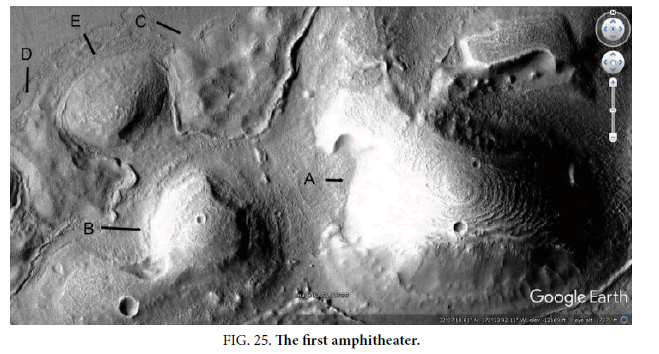
The author discovered all the formations including the amphitheater shapes in this paper, the first one found is shown in Figure.25. So far 4 of these have been analyzed, with the same arcs on their surface. However, there may be hundreds in this and other areas, too many to show here. It is common enough then for this to not be from random chance or from an illusion in some images.
This formation (Figure.25) is also close to Elysium Mons but more to the north, and would have been in the same paleosea. A shows the main amphitheater shape with the circular arcs on its surface. B shows another hill with the arcs on its roof, it has an unusual dumbbell shape with another hill and an artificial looking connection between them. This is unlikely to occur with a pingo, having a bridge of frost upheaving like this. C and D may represent hills that collapsed, perhaps from a flood melting the mud they were made of. Again, there are no cracks from this subsidence, even though a hill as large as A may have deflated onto the ground. Such a process is apparently unknown geologically and may falsify the null hypothesis.
E may be an intact hollow hill, it has a depression in its lower side perhaps indicating it is deflating as well without cracks. The roofs would need to be thick to withstand meteor impacts, there are several in Figure.25, which have not caused the roof to collapse. They might be more resilient to meteor impacts because of a springiness designed into them, it might dissipate some of the shock of the impact causing less damage. It’s likely the proposed builders would have taken this into account in their design, if they lived in a time when impacts like this were more common. It appears unlikely a pingo could withstand an impact like this, the heat should have melted the ice lens inside and caused a subsidence or created outflow channels and ponding.
A Trapezoidal Depression
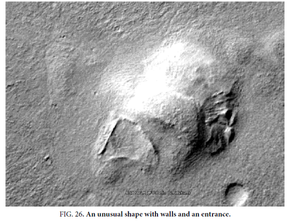
Figure.26 shows a trapezoidal wall shape with an entrance, the hill to its right has a trapezoidal shaped section of its roof. This also has near vertical walls like another walled depression, unlike the shallower sides of an ice lens like in Figure.26. If this roof collapsed, then it might have turned to soil and we would see a walled depression like next to it. The roof shape has a gentle arc shape, perhaps to give its strength similar to the left hill in Figure.24.
The pit and the hill should have been created by related geological processes; however, one part is a walled depression and other is an unusually shaped hill with wall like sides. Above this hill is another section with a lower elevation but part of the overall shape, this part may have subsided. In some of the subsided parts of these roofs the mud may have sagged rather than broken, this would give a depressed area on the roof. To the right of this proposed intact roof this may be a collapse area, it could be broken pieces of the roof and ridges that held it up. This trapezoidal shape is not like those in Figure.9, there are some similar shapes in Figure.2 but this is a single depression not part of a set of polygons.
Broken Roof Edges
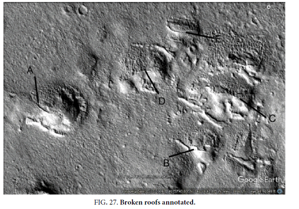
In Figure.27, the roofs appear to be intact on the southern sides. A natural geological process would have to form a smooth curved texture on one side of these formations with jagged edges exposing a mottled degraded surface on the rest of them. A points to one of these edges, below this the albedo is much smoother than above. B shows another example but where the interior seems to have collapsed more. Figure.3 shows a pingo, however they are not known to have a smooth surface with this mottled appearance under it. The jagged edge of this roof shape appears to be jutting out well above the rest of the surface of the hill. C shows another wall, it may be these smooth remains were mud or clay while the rest collapsed as rock fragments or bricks previously cemented together. D also appears to have part of the roof remaining on the upper side. Figure.2 and 7 also have separate rock fragments or polygons on their surface, the problem here is part of the surface is very smooth like cement and erosion appears to have taken off this outer layer to expose the rocks underneath. As will be shown, virtually all of these hills that are degraded have more erosion on the northern side. This would imply a weather system existed at some stage, perhaps for a long time after these were abandoned and not repaired. Why a wind would have blown from the north is not known, Olympus Mons should have controlled the weather but it is to the east.
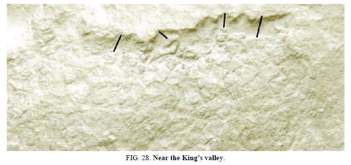
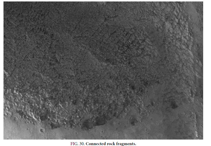
The mottled surface on these formations is hard to analyze at this low CTX resolution, below in Figure.28, is part of HiRise image ESP_023471_1835, of a similar hill with a collapsed summit. This is near the King’s Valley, an area analyzed in [1]. The roof appears to have fragmented as it broke off a smoother upper surface, the dark lines show where these fragments appear to connect to the smoother part of the roof. If this is hollow then what is holding it up is unclear, these blocks may be cemented together. The mottled areas in Figure.30, may also be like this. They might then be fragments of this smoother surface that broke apart, or the smoother surface was covering these fragments. The pieces of rock are of a fairly uniform size, pingos tend to break apart with larger cracks as in Figure.2, rather than shatter into fragments like this. If this had been a form of concrete then it may have had rebar reinforcing of some kind holding the pieces together. When the roof shattered then this may have held it together in a deformed shape.
Collapsing Roofs
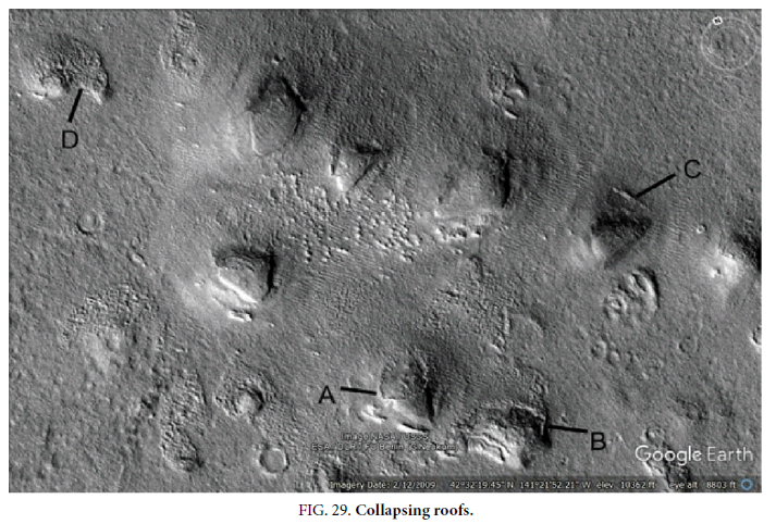
Figure.29 shows hills that are in some cases intact, then others in various states of collapsing. A has a smooth roof surface that looks like other hills without any degradation. Then part of it seems to have had this outer layer stripped off exposing the insides. B shows a squarish section that appears to have collapsed. C shows a rectangular pit next to a hill that has collapsed in part. D may be a hill that has completely collapsed, it has a similar outline to other hills. The hill between A and D has arcs on its surface like the amphitheaters. The other hills may also have these arcs, but higher resolution is needed. The mottled appearance at D as it collapsed indicates the roof part might be breaking into brick like shapes.
PSP_003529_2195 shows a similar change from a smooth skin to this mottled appearance, in Figure.30. There appear to be similar rock fragments joined together as in 0Figure.28.
A Fifth Amphitheater
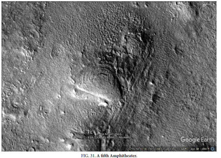
Figure.31 shows a fifth amphitheater shape; the layers appear to be lower on the edges indicating they may have been designed to build the roof in a series of rings. As one ring is completed then the next smaller ring might be added overhanging the central cavity, and so on. They are not like the polygons in Figure.2, it may be that rings of polygons were cemented together in irregular arcs. However, there are no visible segments in each ring though the spacing between the rings is easily visible. These rock fragments or polygons may have been cemented together with a smooth surface. A pingo like in Figure.3 forms by the upward heaving of an ice lens, these have a smooth shape and do not form step like layers such as this. The enigmatic domes Figure.8 do not have these arcs on their surfaces. Figure.27 shows a similar terraced slope at C, however the hill appears to be a mix of layers and non-layered sections. It is difficult for these formations to have formed from layered sediments and then be surrounded by terrain with no layers.
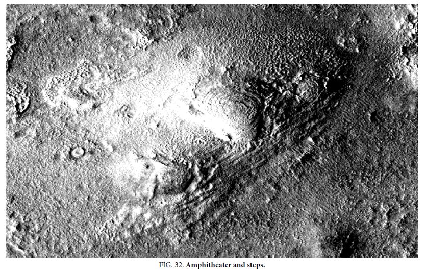
Figure.32shows another image of this formation from P19_008513_2178, it seems to have wide steps leading up to it. There could also have been two Corbel domes to the sides of the main one. These steps could also be a variation of the Corbel design, using straight lines of layers to create a hollow area under it. They are not dunes because they appear to be on a slope from the ground up to the amphitheater, dunes could not climb a slope like this. The image is approximately 5 meters a pixel in resolution, steps would then be 10 meters apart as an estimate which would seem to rule out walking up them. However, there might be smaller steps not visible between them. These layers, if part of a proposed building design, would need supports because the strength of an arch is not used. Alternatively, they could be steps used for design purposes as we use for many public buildings. These formations could be modeled with shape from shading to give a 3D representation of them. Then it could be worked out by engineers whether they could be artificial or not, whether mud or concrete could create domes of these shapes. This can be one way to falsify the artificiality hypothesis. Another test can be how similar the arcs are in the amphitheater shapes, whether this is random variation or they seem to be a standard width. The inhabitants could have been 3 times taller than us with the same kind of loading on their bones, this is because the Martian gravity is about 1/3 of our own. However, we cannot know if these hypothetical creatures could have used these steps or not.
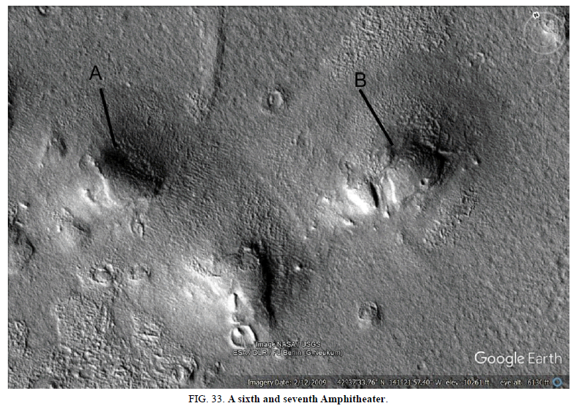
A Sixth and Seventh Amphitheater
Figure.33 also appears to have 2 amphitheater roofs, at A and B, making it 7 so far. The 3rd hill at the bottom of the image also has some arcs on its surface. None of these are a typical pingo shape, the process of pingo formation does not produce these arcs, and it does not produce this outer skin over the arcs. Since pingos are the only geological explanation that has been put forward in this area, then the only known explanation is proposed to be falsified.
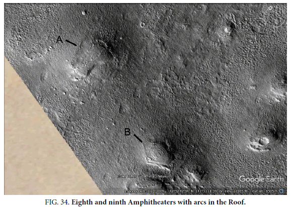
An Eighth and Ninth Amphitheater
Figure.34 has 2 more amphitheaters at A and B, making it 9 in total. The formation under B also seems to have these arcs. Each of these appears to have arcs not polygons like in Figure.2, the large number of these makes it more unlikely they are a chance variation of polygons. The pingo in Figure.2 does have a central rounded rock like in some of these formations, also the first circle of polygons in it does form a similar shape to these arcs, but there are no cracks between the rocks in the arcs here.
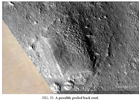
A Peeled Back Roof
Figure.35 looks like the roof has peeled up from the left and over onto the main roof. If this was a mud roof, then it might have been softened by the rain enough to be peeled back by the wind. This would also explain how they seem to have collapsed in some areas, the mud may have softened but perhaps had some reinforcement that bent. This is hard to explain with the pingo model as shown in Figure.5 and Figure.6, the ice lens would have to push up this layer of rock but then leave it pliable enough to flip over like it was a cloth. There doesn’t seem to be any kind of sediment in Earth geology that could flip over like this without breaking, the natural hypothesis would appear again to be falsified. Also, the rest of the formation did not collapse even after this piece flipping over, the stress required to do this doesn’t seem to have even cracked the rest of the formation.
In Figure.36 parts of this peeled roof are shown. A shows where there is an entrance shape, like on many others of these pits. B shows the mottled appearance like some collapsed roofs have, there seems to have been a hollow area to its right as well. The walls are highly degraded here, this may give some insight into what they were made of. The remains appear to be like posts, which may have had material connecting them.
C and D show how similar these two sections are, the dark outline could be folded back over and closely cover the light grey area. The side angles are about the same with the upper part of A and B, and the lower parts like a symmetrical hinge. E shows another amphitheater shape making it the tenth. This section would then appear to be like the collapsing pingo Figure. 3, but again with concentric rings not separate rocks. This then looks like a rounded pingo in some ways but it is part of this overall non-round hill. The ice lens would have had to heave up in this section to form the rounded shape but the rest of the hill also formed by this ice lens is the same height but didn’t form these arcs.
To peel a roof like this on Earth would require very strong wind, perhaps on Mars it was associated with the extinction of life there. Figure. 11, Figure. 13, Figure. 14, and Figure. 17 have hollows like that part exposed on the left of this formation, but with no roof. Perhaps their roofs were torn off in the same way or in the same event, rather than being peeled over like this. As this paleosea sublimated there could have been extreme weather that caused the peeling effect on many of these hills, probably coming from the north as the more damaged side. The flipping over of the roof however would have been caused by high winds from the west. It can then give a glimpse into the conditions these formations went through. It would be difficult to assess these conditions geologically otherwise.
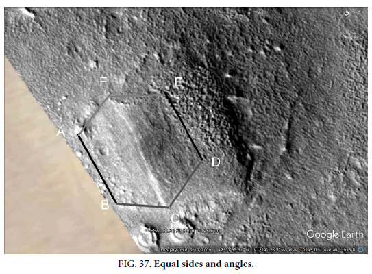
In Figure. 37 the distances between the vertices of this shape are shown. AB is the same line length as DE, if this section peeled over then it would have fitted here precisely. AF and FE are a different shade to distinguish them from AB and DE, this is the same line flipped over. Not only does it fit very well but the angles AFC and EFC are close to each other. BC and CD are the same line flipped again, they show how closely this could have fitted. Again, the angles BCF and DCF are very similar to each other. The distance from C to F is about 600 meters. This makes the interior of these formation quite large. However, the Martian gravity is only 38% of our own so building materials can be thinner according to the square of this difference. In round terms if the Martian gravity is 1/3 of our own then materials in a dome like this could be 9 times thinner, or be much weaker compared to our own buildings.
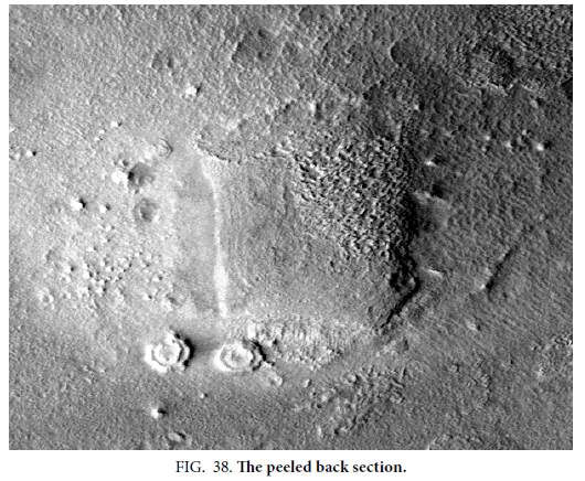
Figure. 38 shows this formation from D22_035927_2228, the impression of the peeled back section is also clear. The entrance shown as A in Figure. 36 is also clearer. The amphitheater like concentric circles again appear to be showing through this flap.
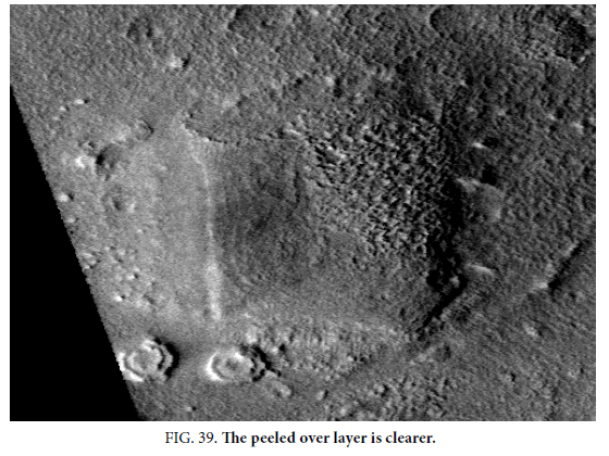
In CTX image B20_017374_2216 the appearance of a peeled over layer is more striking, shown in Figure. 39. The upper entrance is also clearly shown. The roof would have been very thin as the arcs under it are showing through. The walls are highly degraded here, they may have been broken by the same forces that flipped over part of the roof. Other pits with walls are further to the East, the paleosea to the west may have flooded this area causing this damage. In that case a tidal wave from the west, perhaps from a large meteor impact, may have peeled back this roof. Figure. 11 shows the positions of these formations, to the west of this the elevation is lower as the position of this former paleosea. This then may be why they end abruptly along this line, they may have been on the edge of the water or may have been destroyed by waves from it.
A Tenth Amphitheater Shape
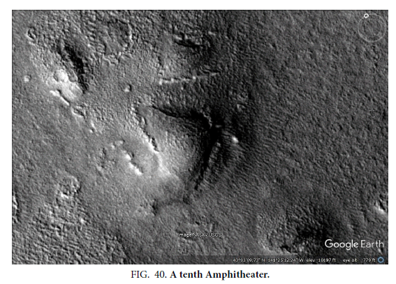
Figure. 40 shows another amphitheater shape, against with an impression of the outer layers being lower. This makes 10 amphitheater shapes, they are so common in this area that all might have these arcs but some still have a skin of the roof over them. As with many of these formations, there seems to be a central plug forming the apex of the possible Corbel dome, this is similar to the collapsing Earth pingo in Figure.2.
An Eleventh Amphitheater Shape
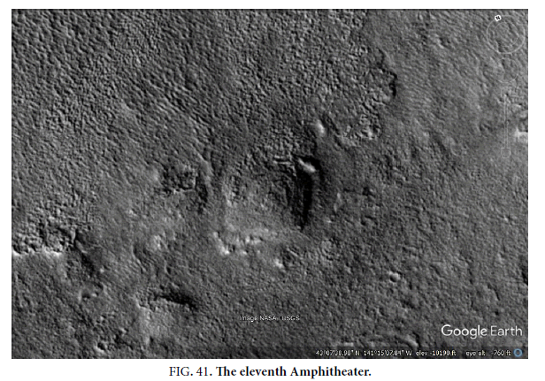
Figure. 41 shows the eleventh amphitheater shape, the center ellipse seems to be much higher than the outer rings. These rings also seem to be much wider, with only about 4 in total including the central circle. It implies the arcs may not be very heavy, alternatively they had some temporary support while being added into place, or there could be a central pillar as seen in some of these formations. If these were polygons such as in Figure.2 and 7, then they would also have to maintain this shape without the rocks falling out leaving holes. They would also have to be very large polygons, perhaps tens of meters in size so the rocks themselves should tend to fall down without an ice core holding them up. About the only way for this not to happen is if they are stacked like a constructed arch or dome.
A Twelfth Amphitheater Shape
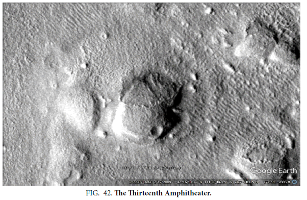
Figure. 42 has the circular arcs of the twelfth amphitheater showing through the outer skin. Like with many of these formations the north side is much more degraded, the skin having disappeared. Two of the other hills in this image may also have these arcs.
A Thirteenth and Fourteenth Amphitheater Shape
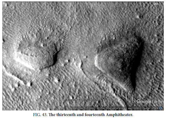
In Figure. 43, both hills have amphitheater arcs, the hill on the right has a darker circular shape on its surface. The hill on the left has the arcs showing through the degraded skin, these appear to be much power on the outer arcs looking like a Corbel dome. That would make 14 in total. Comparing the right-hand hill to Figure.2, to be a pingo this would have had to grow in an approximately symmetrical triangular shape but with this rounded ice lens inside it. This would seem to falsify the natural hypothesis.
A Fifteenth Amphitheater Shape
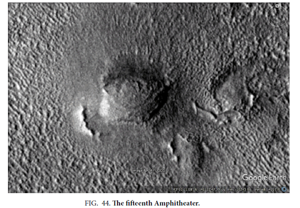
Figure. 44 appears more like an eye shape, the outer rings form more of an ellipse with the center being more circular. This would make 15 amphitheater shapes. Figure.2 has polygons arranged approximately in a circle, but this eye shape would have to grow out of the top of the pingo. On the left the eye shape appears to jut out from the top of the hill, it looks like it is a separate kind of formation to the hill under it.
A Sixteenth Amphitheater Shape
Figure. 45 has a single ring on the top of the left hill as the sixteenth amphitheater. The right hill is hollow inside. The middle hill looks like the hill on the right except it has not collapsed yet. It could be regarded as a progression of collapsing pingos, the one on the right being the lower diagram in Figure.6 as a pingo scar. The central plug on the left-hand hill is similar to in Figure.2, however there are no polygons or arcs around it which would have been part of it forming naturally. It might then be an artificial plug to cap a hole like in the right-hand formation.
Figure. 45 A ringed apex on the sixteenth Amphitheater and a hollow hill.
A Seventeenth Amphitheater Shape
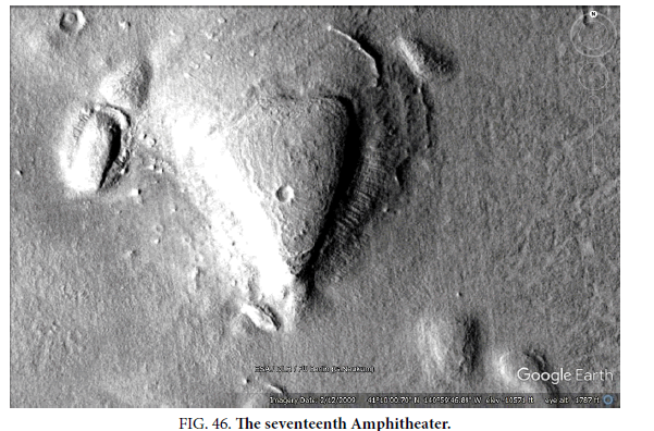
Figure. 46 is similar to an amphitheater but the rings are less smooth in shape, this would be the eighteenth in this small area. The crater in the surface does not seem to have damaged the roof, nor did it punch a hole through. The northern side of this formation appears to have collapsed, if this was a pingo that would indicate the ice lens had sublimated. However, the remaining piece should also have subsided as this should have exposed the ice core to the atmosphere, it also has a near vertical left edge that is incompatible with frost heaving from an ice lens. A meteor impact like this should have heated the ice lens below it causing a slump or break in the surface. In each case however where there are craters on these formations there is no sign of melting around them. This is different to many craters on the ground in previously ice rich terrain, they tend to have water flows in and around them. This tends to falsify the natural hypothesis that these were pingoes with an ice core. There are some grooves radiating out from the bottom hills, these appear with many hills in this area, they often connect hills to each other and craters. They may have been roads, if these were buildings then it’s likely over time movement between them would leave signs like these grooves. Some more examples are shown later.
An Eighteenth Amphitheater Shape
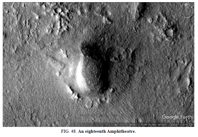
Figure. 48 has the eighteenth amphitheater shape in this area, it is higher than some of the others and the roof less of a dome shape. When the roofs appear to be very flat they may need supports inside, some hollows have interior wall shapes. This roof is in good condition with no degradation of the outer skin. This is very unlike a pingo such as in Figure. 3, yet it has the same kinds of arcs on its surface as the other hills with different shapes. A common process then would need to form these arcs on so many different hills.
The Nineteenth Amphitheater Shape
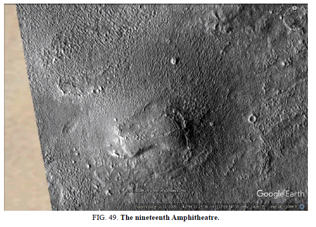
This amphitheater has the roof degraded on one side in Figure. 49, the arcs show through more there. There is more of an impression of the outer layers being lower unlike in Figure. 46. Many of these have the outer skin more degraded on the northern side, but it remains intact on the southern side. This may indicate the pole was approximately in the same direction at the time or that there was a prevailing wind and storms from the north such as a sea breeze. Pingos are usually circular or elliptical, the circular arcs however are part of an L shape which is hard for an ice lens to form.
The Twentieth Amphitheater Shape
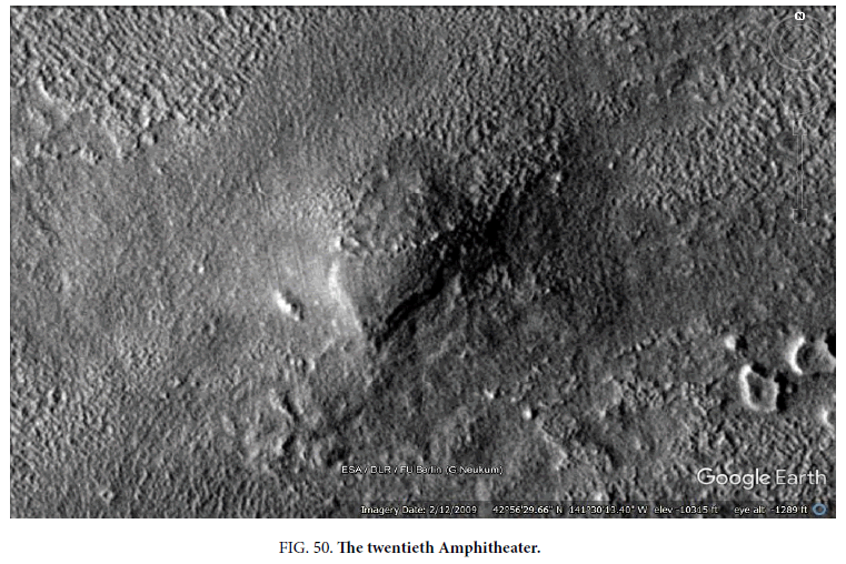
While degraded on the northern side, like the other formations, this has the same arcs on its surface (Figure. 50). The outer arcs appear to be lower, this is consistent with building up circles of bricks in a Corbel dome as shown later. It again has these arcs unlike the polygons in Figure.2, the overall shape is very different on the bottom to a rounded ice lens forming a pingo.
The Twenty First Amphitheater
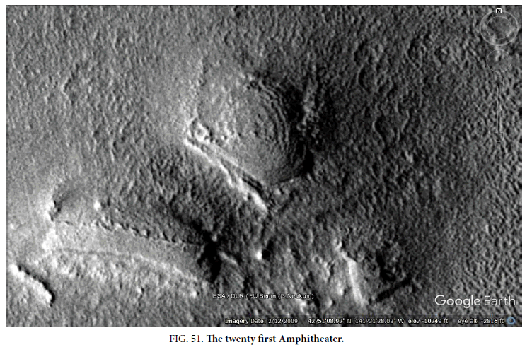
The arcs are very clear in this formation in Figure. 51, also the outer rings appear to be lower. The hill on the bottom left may have some arc layers as well. The skin seems to have disappeared without any debris remaining, this may have been a mud covering over Corbel bricks. The lower formation has circular arcs, but this would need to be from a semicircular ice lens in a pingo. The upper formation has a similar pointed end to Figure. 50.
The Twenty Second Amphitheater
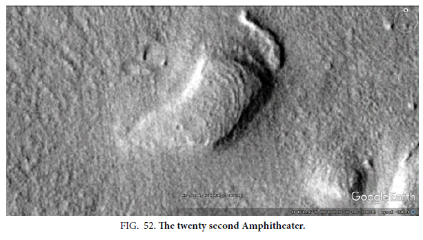
Figure. 52 has the arcs on the right-hand side rather than a full circle, this can still give strength to a roof. The small hill on the right also seems to have arcs on its surface.
The Twenty Third Amphitheater
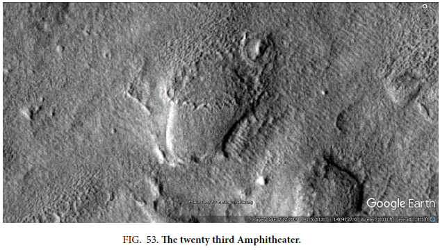
Figure. 53 has the arcs more distinct where the roof has lost its skin.
The Twenty Fourth Amphitheater
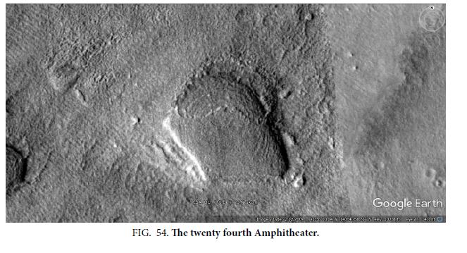
The arcs in Figure. 54 are very complete in circles, also the roof appears to be very flat like a Palsa as in Figure. 4. However, Palsas don’t have a mechanism to form these arcs, they have an ice lens which upheaves less making them flatter.
T Shaped Tube Inside a Hill
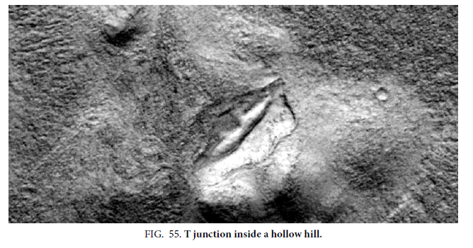
Figure. 55 shows another apparently hollow hill, there is a distinct lower edge exposing the cavity. There also appears to be a tube inside the hill with a T junction, one tube goes upwards and the other tube extends to the left and right. There are hundreds of tubes connecting hills, pits, and craters in three main locations on Mars so far. This may indicate how they connect inside a hill, many images show tubes connecting to hills and even climbing the sides to connect higher up on them. It is proposed they may be conduits for water or perhaps for the hypothetical creatures to have moved around in. If so then it might mean they needed to avoid radiation, at this time. Hollow hills would be idea for us in colonizing Mars, especially if we could move around in tubes like this between the hills. They may also connect to underground caverns. No geological explanations appear to fit these tubes, they are not lava tubes because there are no volcanoes in the area that they could radiate from.
The Twenty Sixth Amphitheater
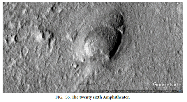
Figure. 56 appears to have two ellipses on its surfaces, perhaps two separate arcs to hold up the roof. Overall perhaps half of these hills have the arcs on their surface, it probably means nearly all of them would on reimaging or removal of this outer skin. It appears to have a similar eye shape to Figure. 43. There are too many amphitheaters in the area to show here, perhaps over 60. The larger number is intended to demonstrate their shapes are not coincidences, that something is consistently causing these arcs to appear on these hills. No geological explanation appears to exist for them, they do not occur with pingos. They may then falsify the natural hypothesis.
Image P19_008513_2178
In Figure. 57, the bottom hill has partially collapsed showing the interior, all three hills seem be connected like with a corridor. The middle hill appears to have a large crack running along its right side, similar to cracks in the bottom hill. It implies the middle hill is hollow. Its shape is not like the pingo in Figure. 3, being more like a rectangle. There is a finger of rock pointing into the center on the lower hill, if there was an ice lens holding this up previously then it should have broken. So, this indicates there is rock under this finger where the ice lens should have been. There are also grooves extending outward from these hills like roads, many more are seen in Figure. 58.
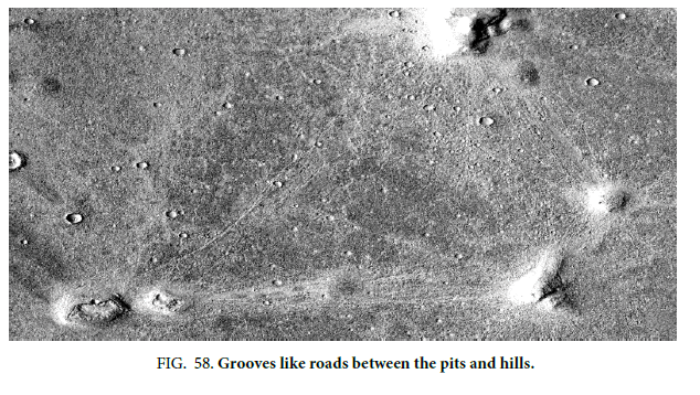
In Figure. 58 there are many pale lines between the hills and pits, often connecting to the rims of craters between them. The pits have a flat and wide rim on them, these are unlike a pingo scar. The could represent regular roads between them, as they were traversed they may have formed grooves into a harder bedrock underneath. They are not faults because they would not be connecting hills and pits, they are also not rivers for the same reason. They are not part of any polygonal cracking. There are so many in this and other areas that it would fill another paper this size, only one example is given.
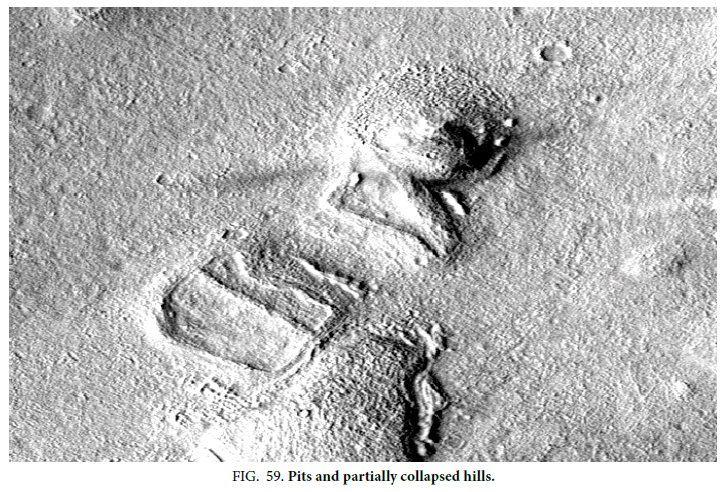
Figure. 59 shows a pit on the left with a straight ridge running down its middle, this may have been part of a support for the roof. It is shaped more like a slice of bread with a circular top, then straight on the sides and bottom. This would be typical for making artificial walls that are straight, but an ice core should be circular. Part of the pit has the mottled appearance like some of the hills losing their smooth skin. In the middle of the image there is a pit with part of a roof on it, this connects with an intact fragment to the upper hill. This has the same mottled appearance in its upper side like it has collapsed as well. On the bottom of the image would be an intact hill. It is similar to some pits in Figure.9 but the formations are not circular like a typical pingo.
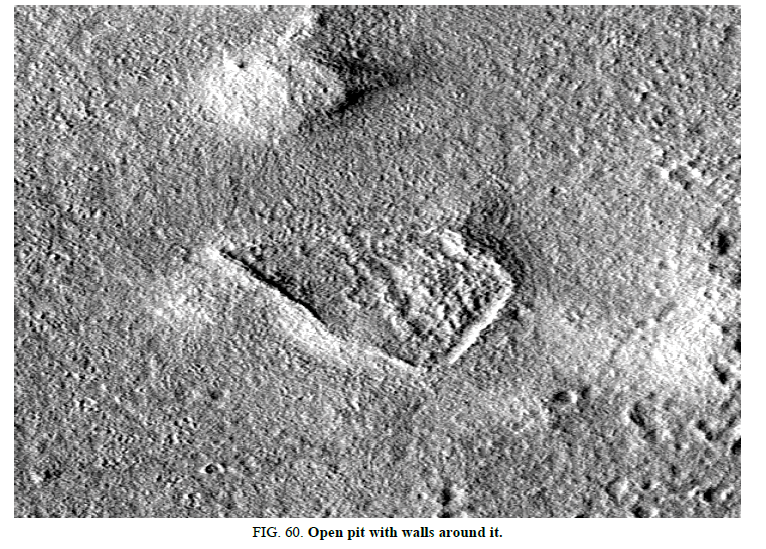
Figure. 60shows a triangular shaped pit with walls around it, and a central wall support. There seems to be an entrance at the vertex of the triangle. The small hill seems to have the same kind of central ridge running through it, implying it may be hollow as well. It seems to have a small curve through it like the larger hill, it also lines up closely with it like a straight line could be drawn through the two of these ridges. There may also be an underground tube connecting them like in Figure. 61. The smaller hill has the same approximate shape as the larger pit. A pingo scar such as those shown in Figure.6 would not have this central ridge. There also appears to be several grooves connecting the two hills, these may have acted like roads with traffic between them. There is no geological reason for hills like this to be connected by these grooves. There appear to be thousands of these grooves in the area connecting hills with each other and craters.
Tubes Up the Side of A Hill
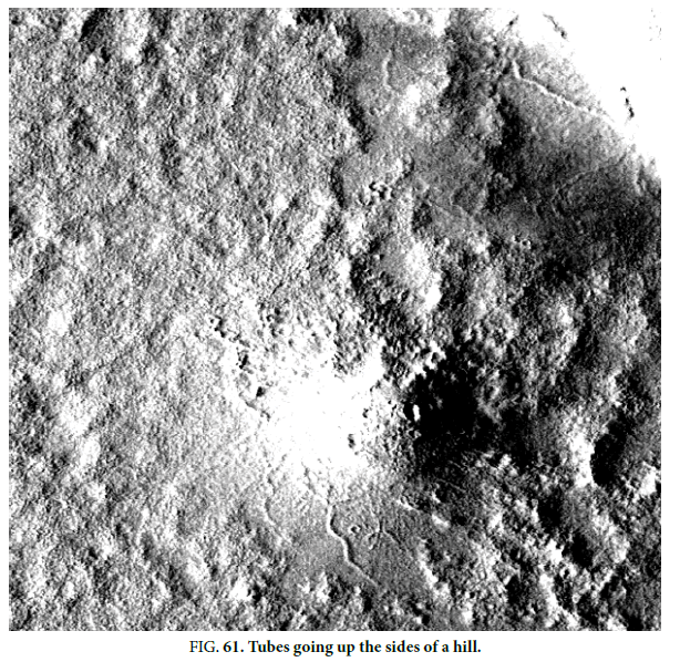
Many of these hills appear to be connected, some with grooves like roads and others with tubes like a covered road or aqueduct. In Figure. 61, these are shown climbing up at angles on the hill, this cannot happen geologically because the force of gravity would only be downwards. For these tubes to be natural they would have to be formed like this on a surface without breaking. If they were exposed harder rock, like a river in positive relief, then they would move in a shape like a river. These tubes move between hills, pits, and craters. There are other tubes on the right going into another hill and along the ground. Also, they appear to go underground so perhaps there are caves or artificial cavities underground as habitats. This might explain the mystery of where the inhabitants would have been, in some areas they might be all underground. There are hundreds of tubes like this connecting hills, pits, and craters in three main locations on Mars so far. With no geological explanation for them the null hypothesis would appear to be falsified with them. If these are artificial then they may make it much easier for us to colonize Mars, these tubes may be usable today and can shield people as they travel from radiation. If these hills are hollow they might also shield people from radiation, it may even be possible to pressurize them with air. If they connect to underground caverns these may also be habitable. Many might be usable to grow food as well, using nuclear power lights could grow hydroponic crops in them. The nature of these formations then is important, even if they are natural then their appearance indicates ready-made structures we could use to colonize Mars. They would then be a priority to reimage with HiRise to establish what they are.
Tube Connecting to Hills
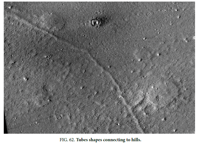
The tube shapes in Figure. 62 are very long, they would go for several of these images connecting to hills. These are above ground, not gullies because the shadows are on the right like the crater rim. They connect to two hills with tubes, one is a clear T junction. It connects to many other hills along it.
Tube Shapes Between Hills and Craters
Many hills appear to be connected with grooves like roads. This is not surprising from the proposed nature of these hills being buildings, it is a likely consequence from this hypothesis that the inhabitants would move from one to another forming recognizable wear on the surface. A lack of connections between them would tend to falsify the artificiality hypothesis. Some are also connecting with tube shapes, these lines in Figure. 63 are above ground, the shadow is on the right like on the rims of the craters. One tube goes into the hill at the top and up its side against gravity. Another on the right goes to the rim of a crater. There is an outcrop on the crater the tube goes into. There is no geological formation found in my research that makes tubes like this. One possible use is covered roads between hills and craters, perhaps to collect water or food.
Esp_017374_2210
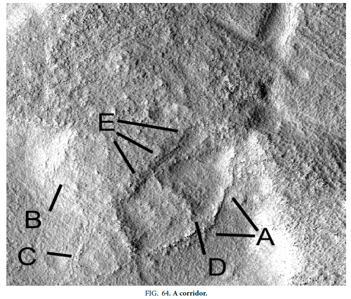
So far there have been few HiRise images taken of these formations, Figure. 64 shows another of these walled depressions next to a hill. This is again very unlike a pingo such as Figure. 4, nor like the rounded shapes of palsas such as in Figure. 4. A shows a decaying wall under the higher resolution, B shows the probably hollow hill it is connected to. C shows another hollow that connects to the larger two depressions with two walls like the one at D. E shows an apparently collapsed corridor going from one depression into the main hill, hard to explain geologically. It then looks like a corridor connecting the various rooms in the overall building. These may also be tubes that connect to other hills like in Figure. 63. This should not be a fault or Riedel shear because it does not extend in both directions to show a slippage. It may also be an indication of tubes connecting these hills underground, similar to the tube shapes in Figure. 63. There may be many cave like enclosures underground as part of this complex. Kaarst geology is known to be associated with caves so this is possible in the area.
A Square Rule for the Height of Buildings and the Thickness of the Roofs
The large size of these buildings and steps implies these hypothetical creatures could have been much larger. Assuming Martian gravity is 1/3 of our own then the load on their skeletons would have been 1/9 of ours. They could then have evolved to be 3 times taller with the same kind of skeleton, dinosaurs grew larger by having much thicker bones.
To compare then with our own, these buildings could be reduced in size 3 times. Figure. 35, with the flap seemingly moved to the right, would be an equivalent of a 200-meter-wide Earth dome. A creature then would use 3 times the space if they were like us, so these larger buildings would accommodate fewer of them.
Martian DNA and the Height of the Martians
If Martian DNA evolved to make larger creatures then it might also evolve faster, for example larger brains might become sentient much earlier with more connections. If this was compared with our own evolution, then dividing Earth’s evolutionary time by 9 might allow sentience to evolve within the billion-year period of the paleosea in Elysium and Amazonis Planitiae. This is highly speculative, but faster evolution of sentience on Mars is conceivable in this time frame. It’s not known if evolution would be faster under lower gravity, however smaller animals might also be more intelligent with larger brains. If this evolution was driven by more intelligent animals selecting mates more efficiently then it might grow much faster. Panspermia with Earth might also have transferred DNA with a propensity to be larger, this would explain how dinosaurs would have evolved, then died out in favor of smaller creatures as natural selection evolved to smaller creatures.
It may have required a chance mutation accelerating the evolution of intelligence, such as what happened with humans to elevate them from the apes. If Mars was seeded then this sentience may have been programmed in to evolve quickly, or some of the inhabitants may have been sentient from the beginning. This runs into the problem of low levels of technology, if someone seeded Mars with life then they could have given them enough technology to make these kinds of primitive buildings unnecessary. It would also have left more modern ruins on Mars with geometric shapes like we would build. The evidence then is still mysterious, if these are artificial we may only have small pieces of the overall puzzle.
Figure. 65 shows the size of man compared to the dinosaurs, this has always been regarded as a problem for evolution as to why they were so large. The theropods body size is believed to have shrank continuously over the past 50 million years, from an average of 163 kilograms (359 lb) down to 0.8 kg (1.8 lb), they eventually evolved into birds This according to Borenstein [10] is based on evidence that theropods were the only dinosaurs to get continuously smaller, this may have been a natural selection effect as they adapted to stronger gravity. It is unknown how large animals might have been on Mars, with higher radiation they might have been mainly in the paleosea where water would protect them. Some dinosaurs were partially aquatic however. Again, this is a speculation based on evolution in low Martian gravity and panspermia.
Dome Construction
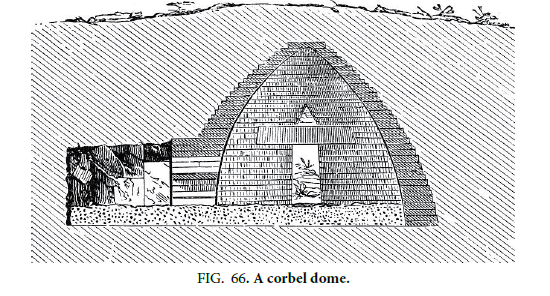
Figure. 66 shows a Corbel Dome construction, a tomb under the Treasury of Atreus, how the layers are cantilevered or corbeled in towards the center. This was used in the Bronze Age and so is a simple technology to develop.
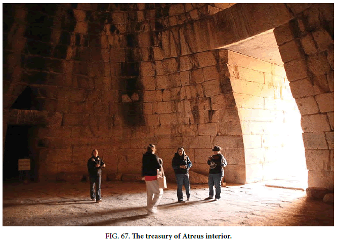
Figure. 67shows inside the Treasury of Atreus, similar large spaces could exist inside these amphitheaters.
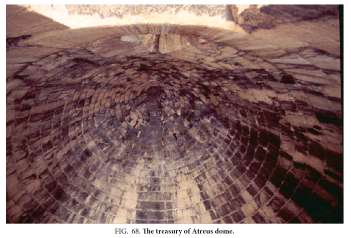
Figure. 68 shows the similar ringed shapes that appear on the tops of the amphitheater formations. This is the dome of the Treasury of Atreus.
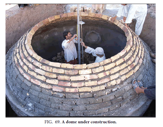
In Figure. 69 a Corbeled dome is being constructed [11].
Archeological Significance
In the past, one of the main problems with possible Martian artifacts has been their small number. This can give a very skewed impression of that civilization if it existed. Over time these numbers have increased enormously, the picture being revealed is a much more comprehensive hypothesis. For example, in the King’s Valley there are many crowned faces and some fish images, this implies some kind of worship or honoring of some of the inhabitants. The fish imply they were eating these in the paleosea, this gives a clue about their possible ecosystem and diet.
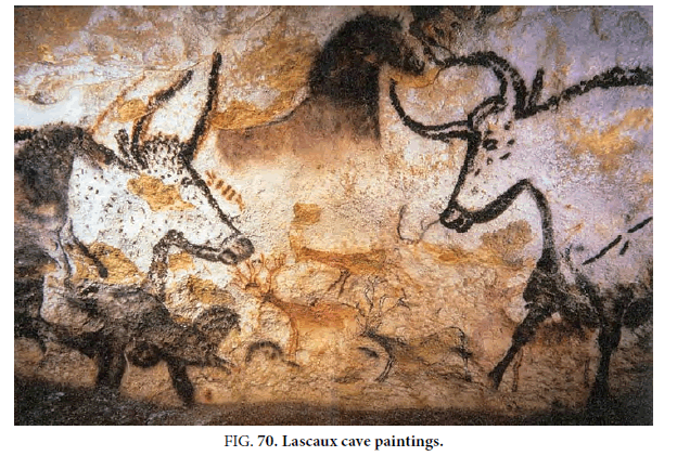
At this stage the evidence is still being accumulated, however if artificiality is proven then clues like this will be enormously useful. Inside these domes may be large amounts of archeological evidence, transforming our eventual understanding of these creatures and the ecosystem they lived in. Figure. 70 shows paintings from Lascaux in France [12]. Paint like this may not have survived, however shapes carved into the walls like the fish shown in [1] managed to survive in the open. If similar shapes were carved into the interior of these possible domes then they might be in pristine condition, the conditions inside would have remained very dry. If paint was made of clays rather than organic materials it may also have survived. There may then be large numbers of pictorial scenes in these hollow hills giving us insights like in Lascaux. Because there are so many hills it is possible we may develop a very detailed history of these creatures. The evidence then may seem enigmatic and ambiguous now, but if proven they may become extremely well understood, like in our own history.
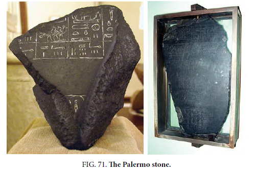
In the same way if sculptures like the Crowned Face survived in the open then it is much more likely sculptures would survive inside hollow hills. Figure. 71 shows the Palermo Stone from ancient Egypt [13], tablets like this with language symbols might well survive inside a sealed dome. With so many hollow hills, the chances are very high clues to their languages will be found and deciphered.
Whatever material was used in the construction of the Crowned Face, or the rock that the fish were carved in, should have been able to survive even better as tablets or sculptures protected from radiation. It’s not known if clays could survive, however if the roofs of some of these domes are made from mud bricks then sculptures inside of the same material should survive.
There could be graves inside if some were mausoleums, in that case then they might have been buried with many ornaments that explain who they were and where they fitted into their society. If these domes were inhabited then furniture, cooking implements, tools, etc. may still survive especially if made from stone or clay. Pottery might survive if it was protected from the elements. Some animals and these creatures might even have fossilized perhaps under collapsed domes. We may then see their imprints in these rocks or actual fossils such as in Pompeii when Mount Vesuvius suddenly erupted. Some possible fossils were imaged by the Martian Rovers, if fossils would survive on Earth they should survive on Mars.
Parts of these domes could also be made from concrete, the materials for this are readily available on Mars. If so then concrete furnishings and utensils should survive inside a dome if they are surviving outside it. [14] describes possible dam shapes in some craters, fed by groundwater seeping from an Artesian basin. These water sources have been suggested on Mars, the King’s Valley is one valley that may have been formed by sapping from groundwater. Some of these dam walls are in near pristine condition, the interior of these hollow hills then should be in good condition if the same materials were used.
Figure. 72 shows one of these Martian dam shapes. A shows a rounded edge on top and some signs of layers, similar to in the amphitheaters and also in the Square Mesa formations. B shows how this dam wall can curve without any sagging through almost 90°C shows possible vertical ribs in the wall giving its strength, there is also a well-preserved edge on top at D.
Roof Construction
Figure. 73 shows part of a roof that may have flipped over, this indicates the roof would have to be flexible. One example of this on Earth would be using chicken wire with a mud or concrete rendering over it. As this flipped over there would be cracks but it would be held together by the wire mesh. Considering the level of technology in these domes wire mesh is unlikely, however a mesh of wood pieces or a thatching of straw could have been used. This would be similar to a primitive geodesic dome, the shape of the dome would be formed by this mesh of wood or leaves then the mud or concrete would be added over it. If so then a lot of organic material should have been trapped inside the mud, there may be imprints of leaf shapes giving clues of the ecosystem at the time. It may also be possible to measure the amounts of each element trapped there and determine the possible organic compounds they were made of. Carbon dating might also be possible from the carbon atoms trapped there, giving a time of construction. In Figure. 73, some of these ferns [15] are shown, these are found as explained in [1] on the same great circle as Nefertiti, Cydonia, and the King’s Valley. A shows a blank area indicating these are not from water flowing. B shows a fault that would have cut these formations after they were created. C shows some craters that expose the ground under the ferns. Plants of this shape could have been made into a thatched roof and then mud added on top, this in combination with Corbel domes could have created these hollow hills.
Figure. 74 shows how a thatched roof is constructed on Earth, these could have covered the pits with walled sides. By covering this with mud or cement a stronger roof could be made. As this seeped into the vegetation it could then have flipped over as in Figure. 35.
Carns
Figure. 75 shows an entrance in a formation called Carn Euny [16] in Cornwall, a hollow hill in effect made from stones.
Figure. 76 shows how large the interior of a carn can be, this is comparable to these amphitheater formations on Mars.
Figure. 77 shows the exterior of a carn [17] formation, this may be similar to the amphitheaters. Individual rocks are not visible in the Mars images, however some of these formations with the outer skin removed have a mottled appearance perhaps like rocks.
Permafrost
On Mars, there are many areas with subsurface ice, even near the equator. Elysium Planitia also contains ice deposits so there could be permafrost under these hollow hills. If so then caves or underground rooms might have survived in a frozen condition since they were formed, unless changes in the Martian obliquity warmed this ice. Smith and Mckay [18] discuss this obliquity changes, estimated at up to 45° with periods of around 100,000 years. Underground it would still take time for permafrost to melt, the existence of subsurface ice deposits on Mars indicates these are unlikely to melt completely. According to them permafrost 1000 meters down should not melt. The ancient ice-rich permafrost in the southern highlands of Mars 60°S to 80°S 180°W is suggested to be the most promising because the magnetic field is strongest there. The reasoning is that this area is the most undisturbed, however [1] advances a hypothesis that this magnetic field died out elsewhere after life evolved. The Argyre impact would have begun this warming of Mars the magnetic field would have died at some time after this continuing to protect life there. This has some support from the polar wander path proposed by Sprenke and Baker [19] which shows the magnetic poles moving, it is proposed this happen after the Argyre impact. Soina et al. [20] also suggest that Martian organisms may have survived in permafrost, with indications of this in Siberian permafrost of 2 million years ( Figure. 78).
It may be some fossils and implements are preserved in the frozen soil under these hollow hills. Cydonia would have been on the same ancient equator as the King’s Valley, its current position in the mid latitudes could have allowed more permafrost fossils to have survived there. While organic material is unlikely to survive, there may be enough of the residual chemicals to carbon date and determine what organic compounds existed there. Willerslev et al. [21] discuss how most DNA damage is caused by temperature, water and oxygen. Life that remained as Mars was cooling, and the atmosphere freezing, then has the best chance of genetic material being preserved to some degree, in some areas these temperatures fall far below zero. Generally, they suggest the smaller the organism, such as bacteria, the long the DNA would survive. However, we don’t know how compatible this DNA would have been with our own, or whether it was more resistant to damage because of the Martian environment of high radiation. We also don’t know how long ago this final end to Martian life would have been, some suggest that Elysium Mons finally cooled just tens of millions of years ago. Smith and McKay [18] discuss how dead Martian organisms might still be found in the Martian permafrost. Arctic permafrost as old as 8 million years may still contain evidence of organisms.
Also, imprints of organic materials like bodies may still survive, though this would seem to be extremely unlikely. Figure. 79 shows the Siberian Ice Maiden [22] found in permafrost, though this is far younger than any possible Martian creatures.
A Possible Ancient Ecosystem
Arkani-Harmed [23] examines the positions of former rotational poles. The Pre Tharsis pole is north west of Olympus Mons, this is consistent with the hypothesis of [1] where the shock wave from the Argyre Impact was directed at the then South Pole. This impact could have occurred either deliberately or by chance, determining this may need to wait until Mars is visited and perhaps colonized.
In Figure.80 from [1] this former rotational pole [24] is approximately at A, there is a line from A to Argyre Crater indicating the direction of the proposed shock wave from this shallow impact. B and C show the 3 Tharsis Montes, it was proposed in [1] that rifting occurred from this impact also forming the rifts and volcanoes along E and I containing Solis Planum at H.
Several studies [24] show the rotation axis of Mars has moved. The Coprates Trough, another name for Valles Marineris at I ( Figure.79), was according to McAdoo and Burns caused by tensile stresses from the polar wander. This is like the hypothesis in [1] except that Valles Marineris was proposed to have been a former chasma of the pole, the shallow shock wave from the oblique Argyre impact would have created a rift valley. This chasma being the weakest part of the pole would have rifted there from the shock wave, the other parts being covered with ice would have rifted less. E may have been another chasma on the pole. Solis Planum according to this theory may have been the location of the pole.
Schultz and Lutz-Garihan [25] discussed how the rotation axis of Mars may have moved from Utopia Planitia to Amazonis Planitia, in [1] this opposite pole to Figure.80 was situated in Utopia Planitia, it then moved to Amazonis Planitia and then north to its current position. As it moved the pole melted forming a paleosea in Elysium Planitia and Amazonis Planitia. The South Pole would have been displaced by the rise of Tharsis Montes and also moved, this would have been into Chryse and Acidalia Planitia causing flooding and the formation of a second paleosea. There is no clear consensus on the path of this polar wander, Schultz and Lutz [25] discussed an irregular polar wander path of 120 degrees.
A NASA Press Release on Nov 22 2016 [26] announced the discovery of a large ice deposit in Utopia Planitia, perhaps part of this former pole. It ranges from 39 to 49° N, and approximately 70 to 90° E. Shallow Radar (SHARAD) was used, the deposit ranges from about 80 meters to about 170 meters in depth, with a composition that's 50% to 85% water ice.
The hypothesis of Tharsis causing the initial polar wander has been investigated, Melosh [27] suggested up to 25° of displacement of the pole if the Tharsis load was removed. In [1] the poles began to wander as the rise of Tharsis Montes, and Elysium Mons from antipodal volcanism or a second impact forming Isidis Planitia, caused these volcanoes to move towards the equator. The poles as they melted moved along the dichotomy boundary creating many fluvial and lacustrine morphologies such as valleys, lakes, sapping, atmospheric precipitation, the poles also creating the paleoseas.
Arkani-Hamed [23] also proposes that this initial pole position around Tharsis was when the core dynamo was weak or non-existing, this would have affected the habitability of Mars by deflecting cosmic radiation and the solar wind. Sprenke et al. [28] discusses signs of a magnetic pole wandering, it is possible then this warming of Mars was accompanied by a lingering protection of life with this magnetic field. It was proposed in [1] that the Argyre impact was accurately directed at melting the pole, whether by accident or design, it is unlikely a deliberate targeting would have been intended to destroy the magnetic field. One speculative hypothesis in [1] is a Dyson probe may have been sent out from another civilization, this would have directed a shallow impact at Argyre and possibly Isidis as the most efficient way to terraform and then seed the planet. While unlikely, nothing would exclude this impact having happened by chance, and subsequent evolution may have developed sentient life for a short time.
Arkani-Hamed [23] discusses how ?ve giant impact basins on Mars (Hellas, Isidis, Utopia, Solis, and Argyre) trace a great circle and proposes these were an ancient equator. In [1] this great circle is traced between the two poles, Isidis Crater is near the opposite pole to that in the Tharsis Montes area. It may have been a second impact deliberately aimed to be a shallow impact at that pole. The alternate hypothesis is Isidis Crater already existed prior to the Argyre impact, it is unlikely two impacts would have occurred by chance aimed at opposing poles. This represents a test of the directed impact hypothesis, if both Argyre and Isidis occurred around the same time with their shock waves directed at opposite poles then the chances of this happening by accident would be remote. If the Isidis impact was earlier and not towards the pole then the Argyre impact, and the consequences proposed here, may have occurred by chance. The alien hypothesis then is not necessary; the possible artifacts found so far show no signs of technology beyond those of Ancient Egypt though they would have been constructed billions of years ago.
In Figure.81 an elliptical crater at the top of the image is shown pointing at a red circle, this circle is Apollinaris Mons. To the right of this volcano is another possible pole position, consistent with the polar wander in [1] and also with [25]. It has the appearance then of another shallow impact directed at the pole as it moved, also impacting on the edge of the polar ice and further melting it. It may offer some evidence of a directed shallow impact at this North Pole rather than having occurred by chance. This area would have contained a paleosea according to Erkaling et al. [29]. On the right edge of this image is the initial pole position suggested by [23]. The yellow pins to the left of the elliptical crater represent formations including one called the Square Mesa. These may have been constructed as artificial islands in this paleosea.
Figure.82 shows how the 3 volcanoes of the Elysium Highlands; Elysium Mons, Hecate Tholus, and Alba Tholus, form a shape like a rift valley’s triple junction symmetrical with Isidis Crater on the left. This may indicate Isidis was a second shallow impact directed at the pole in this area around the same time of the Argyre impact, then the Elysium Highlands would not have been formed by antipodal volcanism as in [1]. Below the dark line connecting Isidis Crater to Elysium Mons are two other lines, these appear to radiate out from the crater in this direction. Similar radiating low areas also appear out of Argyre Crater towards Tharsis Montes, these can be seen between D and Argyre Crater in Figure.80.
The tail of the arrow in Figure.83 is the approximate position of a meteor impact in Amazonis Planitia, this would also give a symmetrical shape of the 3 volcanoes of the Elysium Highlands. The right-hand side of the arrow would be the approximate impact, the shock wave going to the left creating the 3 Elysium Highlands volcanoes. This gives a similar arrow head shape to in Figure.80, with the 2 outer volcanoes of Tharsis Montes and Elysium Mons. Pedersen and Head [30] give this approximate location for a meteor impact.
Figure.84 shows how this impact would have directed the shock wave from Argyre Crater on the left at A. This was discussed in [1], the red areas are drier as shown in this map of epithermal neutrons. They appear to radiate out from Argyre symmetrically with the middle of the red area being directed at this former South Pole. On the edge of this red area are Tharsis Montes and Olympus Mons, it is proposed these were formed from this shallow impact to melt the pole. B shows possible signs of drier areas radiating out from Isidis Crater, however the forming paleosea here would have prevented most of these drier signs from persisting. Alternatively, the drier area at the head of the right hand arrow could have been caused by the impact in Amazonis Planitia.
Arkani-Hamed [23] proposes that Tharsis has controlled the subsequent polar wander of Mars, this was also proposed in [1] but arising also from the Argyre and possibly other pole directed impacts. When these impacts would have melted the poles, the release of water into the Northern Lowlands would have created paleoseas that also controlled the balance of Mars and subsequent polar wander. The large amount of water in these lowlands may have added to the complicated polar wander proposed by [25]. Arkani- Hamed [23] also assumes that the Tharsis bulge, Alba Patera and Elysium rise together provided the main driving force of the polar wander of Mars. He considers a quasi-rigid rotating planet with no elastic lithosphere, adding a small positive mass at the surface which in this case would be Tharsis, Elysium Mons, and Alba Patera. It disturbs the equilibrium, then the small mass reaches the equator.
A small mass can result in a large polar wander if it begins at a high latitude according to Gold [31], in [1] Tharsis and Elysium Mons would have formed at the poles and so would have had a large effect on the polar wander. Tharsis might have moved earlier to its current position along with Elysium Mons to near the equator, they may then have remained near the equator while the poles moved in an arc to their current positions. It may be that the melting of the poles and forming this northern ocean reduced this mass deficit around the current pole, filling it with water, and so the polar wander initially occurred along the dichotomy boundary. Later as this ocean increasingly sublimated to the poles the current North Pole may have moved into the center of this negative mass. It is then the converse of how a positive mass tends to move to the equator, a negative mass or hollow would tend to move to the pole, the North Pole to the Northern Lowlands.
Arkani-Hamed [23] proposes the Tharsis bulge was formed by about 4.2 Ga which is consistent with the Argyre impact occurring then. He also proposes that Alba Patera and Elysium Rise were also formed at that time influencing the polar wander, this is consistent with the shallow impact hypothesis in [1]. This early movement of Tharsis to the equator is consistent with the Argyre impact, the pole would instead have moved along the dichotomy boundary until Tharsis reached the equator, then it rotated while remaining at the equator in both hypotheses. Later as the paleoseas sublimated, when the volcanoes cooled, the poles would have moved to their current positions. The possible artifacts on Mars were shown in [1] to form a great circle implying a South Pole position west of Hellas Crater. This may have been a long-term position of the pole with Tharsis remaining near the equator and then rotating as proposed. Because of the large amount of water in these paleoseas, both their mass and the volcanoes may have directed this polar wander. Arkani-Hamed [23] also proposes this polar wander occurred over 300 million years, this can be compared to the estimates by Erkaling et al. [29] of a paleosea in Elysium Planitia lasting 1 Ga.
McAdoo and Burns [24] propose the loading of the lithosphere by this polar wander resulted in the surface fracture of Coprates trough complex, also known as Valles Marineris. In [1] this is proposed to be a rift valley formed from the previous chasma of the pole in this area. This surface fracture would then have occurred in this position because of the previous polar chasma here, the other parts of the pole may have prevented some rifting from the weight of their polar ice. Some similarities are noted [24] to parallel graben or rift valleys, they mention the East African Rift System also remarked on in [1] as being like Valles Marineris. The characteristics of a rift valley, according to [24], are similar to the antisymmetric, S-type figure of Coprates. In [1] this shape was also proposed to come from the asymmetric shape of the original polar chasma from the Coriolis Force on rotational poles.
Schultz and Lutz [26] suggest the youngest near-equatorial deposits occur southwest of Olympus Mons (15°W, 0°S); more eroded deposits with a slightly greater age occur east of Apollinaris Patera (180°W, 6°S). The first deposit according to the authors is similar in position to A in Figure.80, however much of the former pole position here would have been erased by the rise of Tharsis. In [1] the pole originated in the Tharsis area and then moved to Lunae Planum. The signs of a pole in this area would have been obscured by the formation of a paleosea. Apollinaris Patera in Figure.81 is near the possible pole deposit discussed in [1]. Very old deposits also occur south of Elysium (210°W, 0°S) and are mirrored in the opposite hemisphere by the chaotic terrains of eastern Valles Marineris. In [1] these are different poles; however, the actual path is open to conjecture by many authors. This eastern Valles Marineris would have been the pole that moved to Lunae Planum creating floodwaters, then to Acidalia Planum and to the east along the dichotomy boundary. The deposits in Elysium would have come from a pole in Elysium or Utopia Planitia. Schultz and Lutz [26] propose that frozen volatiles in pre-Lunae Planum were absorbed when higher lithospheric/atmospheric temperatures favored melting. In [1] this would have come from the Argyre impact and the rise of Tharsis increasing temperatures and air pressure, this would have caused floodwaters in Lunae Planum.
Schultz and Lutz-Garihan [25] discuss how 180 grazing impacts are found on Mars, representing 5% of all impacts. They interpret these as being satellites that degraded over time, some of these forming great circles. They also estimate 95% of the mass of these grazing impacts occurred before the formation of Lunae Planum, this is consistent with [1] where Lunae Planum would have been formed along with Valles Marineris by the rifting associated with the Argyre impact. It was also proposed [1] that some of the ejecta from the shallow impact of Argyre would have gone into space, with the shallow trajectory some of this may have formed elliptical orbits and then more circular orbits over time with atmospheric drag. Eventually these satellites would have reentered as meteors forming more grazing impacts. They estimate the total mass of these impactors would have been over 225 km in diameter which is comparable to the size of the Argyre meteor, however much of the mass from the Argyre and possibly Isidis impacts may have gone into orbit after their grazing impacts at the poles. Phobos and Deimos, it is suggested by Schultz and Lutz-Garihan [25], may have come from this mass. They also discuss how only low grazing impacts of less than 10 degrees form asymmetric ejecta and less than 5 degrees form elongate crater shapes. If the Argyre impact was of a similar angle then the ejecta could have gone into orbit, and then decayed forming these other grazing impacts.
Sprenke et al. [28] discuss how the geoid of Mars is dominated by the Tharsis rise, to investigate this they produced a non-hydrostatic model without Tharsis. They concluded that stable spin axis positions would be 15° to 90° from the current poles, this is consistent with their having been at Tharsis and at Elysium Mons. In their Figure. 4 this places the pole at one time south of the Elysium Highlands near the King’s Valley, this area containing the Crowned Face is discussed in [1]. They also discuss a 6% component of flattening, how Mars would become more flattened at the poles and how this would change to a new flattening as the pole wandered. Their results are consistent with their former paper [19] on polar wandering discussed in [1], these give a polar wander path based on magnetic anomalies, geomorphology, and grazing impacts [32].
Pierazzo and Melosh [33] discuss melt production in oblique planetary impact events, similar to the proposed Argyre impact directed at the former pole position around Tharsis Montes. They investigate impacts from 15° to 90°, however Schultz and Lutz-Garihan [25] estimate that oblique craters require a shallow impact of 5° to 10°. They [32] find the crater size is generally proportional to its volume. Compared to the 90° impact, the reduction in melt volume is about 50% for impacts at 30° and more than 90% for a 15° impact. They also say these estimates do not include shear heating, which can contribute to the amount of melt production especially in very oblique impacts. The Argyre and possibly Isidis impacts then would create shear heating along the surface, also rifting the ground producing fractures and volcanoes.
Pan and Ehlmann [33] discuss detections of Fe/Mg phyllosilicates and hydrated silica in Acidalia Planitia, these may have formed by localized vapor weathering, thin-?lm leaching, or transient water. This area according to them is less likely to be in a Northern ocean. It is consistent with [1] where the pole would have moved through this area, being still partly ice the water erosion would have been transient, moving to the east. This area also shows no clear signs of possible artifacts except for the Nefertiti Formation, while Amazonis Planitia has many possible artifacts as well as more signs of an ancient paleosea. If this was reversed it would be evidence against some of these formations being artificial, being associated with a paleosea makes them more likely to have used this water as part of an ecosystem. They also found many indications of mud volcanism in Acidalia Planitia as did Oehler and Allen [34]. This is supported by Acidalia receiving large quantities of sediments from Chryse Planitia through Hesperian outflow channels. In [1] these sediments came from the flooding that occurred as the pole melted from the Argyre impact. This basin wide mud eruption may be like those mud volcanoes found in Isidis Planitia from the opposite pole melting. It can be attributable to overpressure in response to rapid out?ow deposition related to events such as tectonic or hydrothermal pulses, destabilization of clathrates, or sublimation of a frozen ocean or the former pole. In Isidis Planitia as well then this sublimation of the polar ice, particularly before the atmosphere had thickened to allow long lived paleoseas, could account for the large numbers of mud volcanoes in both areas. The authors also suggest signi?cant release of gas may have been involved, and this extensive mud volcanism could have provided potential habitats and upwelling groundwaters. Amador et al. [35] also suggest there were geysers and springs associated with these mud volcanoes.
Carter et al. [36] discuss how Mars >3Ga has widespread hydrous clays and fluvial/lacustrine morphologies, however the likelihood of widespread oceans on Mars is still being debated. In [1] this paradox would be resolved by the moving pole spreading water in some areas, then as the pole moved on these areas again became desiccated. Because the pole would be a colder area this can appear to be a cold and sometimes wet Mars, while other areas heated by the rise of Tharsis Montes and Elysium Mons would indicate a warmer Mars with long lived paleoseas. For [37] Mars perhaps sustained liquid water flow between the middle Noachian (>3.85 Ga) and the end of the Noachian ( 3.7 Ga), this smaller time frame can be consistent with [1] where some areas had a much shorter experience of standing water because of the polar wander. Other areas nearer the Tharsis Montes, Olympus Mons, and the Elysium Highlands would have retained this paleosea for much longer.
Figure.85 shows a dark area similar in size and length to Valles Marineris on the opposite side of Mars. Figure.86 shows the same shape from the Mars Orbital Camera gallery, the oblique impact from Figure.80 is on the right edge. This would be consistent with the pole in Figure.84 being to the right of Elysium Mons.
Figure.87 shows how this chasma could be at a similar angle while being distant from the pole center. This shows the south pole and Chasma Australe.
Figure.88 shows Valles Marineris from the original MOC gallery, Figure.89 shows it in the updated gallery. These shapes are almost exactly opposite each other; Figure.86 is at 12° N 200° W and Figure. 88 has a section of Valles Marineris at 12° S 50-70° W. This gives about 150° of longitude between them, 180° is directly opposite so with the flattening of Mars from polar wander this is close. The dark area in Figure.86 may be from the original polar chasma of the pole, if as it melted dark soil flowed down the chasma creating this area. Valles Marineris also has signs of dark soil having flowed down it in Figure.88, to the right the ground is much darker perhaps from this floodwater having carried more dark soil to Argyre Planitia. Figure. 86 would have been a paleosea so much of this dark soil would have been dissipated, the current rotational poles also attract dark soil blown to them in autumn from dark dunes.
If so then the pole would have been around 5° N 210° W, this pole position is consistent with Sprenke et al. [28], also with Schultz and Lutz [25]. It is also consistent with Valles Marineris having been a rift valley [24] but formed in a polar chasma [1].
Scanlon and Head [37] discuss remnant buried ice associated with the Arsia Mons glacier deposits, these may be associated with the ice from the former pole in this area. As the pole melted from the volcanic activity glaciers could form as warm air drew humid air to the area and created rain. Some areas would then direct this as floodwater to the west where the hollow hill formations are found. Other parts would be colder and form glaciers; this could also have happened as the volcanoes cooled. They propose these were formed tens to hundreds of millions of years ago during spin-axis obliquity, however it could also be from this former pole much earlier [1]. They also suggest there could be a core of ancient glacial ice here. There could also be a long-term preservation of water ice by a debris cover (lag) formed from sublimation of dirty ice, also buried beneath volcanic tephra and Aeolian deposits. It could contain preserved biosignatures, this is consistent with the paleosea next to it containing possible artifacts. Their Figure. 3.1 shows pits and knobs like the formations discussed here.
Conclusion
Amazonis Planitia has strong evidence for a former paleosea, these formations would be on the edge of the sea also being fed by fluvial valleys with meltwater from Olympus Mons and Tharsis Montes to the east. Along with the King’s Valley and the Square Mesa formations they represent a concentration of possible artifacts in an area highlighted by NASA for astrobiological investigations. These depressions are like each other in depth, they have high walls around them of around the same thickness. There is little random variation in these walls in each structure but the overall shapes are very different to each other. The sides are generally curved which would give strength to a wall, this is the principle of an arch or dam. These formations seem to have holes in these walls as if there were doors there, usually only one per room shape. They are either not similar to pingos, the main natural explanation, or have been modified from them.
Putting a roof or dome on these shapes would be easy for us if we colonized Mars, there are also possibly hollow hills near them. If so, then they might have hollows in them we could perhaps pressurize with air and then inhabit. This might then allow for more rapid colonization of Mars if all these hollow hills could be repaired or used as is. There are so many possible structures like this that perhaps tens of thousands of colonists could pressurize these and use the material to protect them from radiation. If they were not strong enough for pressurization, because of their extreme age, then perhaps a thin dome could be placed over them, the structure would still provide radiation protection. Of course, if they were artificial structures, they would likely hold immense amounts of important archeological materials. Investigating these could then unlock many mysteries about the inhabitants, what culture they had, where they came from or how they evolved, and perhaps what happened to them. Resolving these issues then might be a priority before using them as important archeological evidence might be destroyed.
The hollow hills may have had mud roofs that survived, the roofs that collapsed might have been washed away or fallen into the depressions explaining their absence. For example, tidal waves over this area might have carried off some roofs while leaving others intact. Rain might also have dissolved the roofs into mud filling parts of the depressions. Once these waves had gone the remaining roofs might last for a long time. Some hills in these areas may be hollow, many have circular arcs in their upper surface like Corbel domes [38]. Some have collapsed sections that are angular, this can indicate beams holding up the roof.
References
- Orme G, Ness P. Why we must go to Mars: The King?s Valley Createspace; 2011.
- Schultz P, Lutz-Garihan A. Grazing impacts on Mars: A record of lost satellites. Geophys Res. 1982;87:84-96.
- Benjamin MJ, Grosse G, Hinkel Kenneth M, et al. Assessment of pingo distribution and morphometry using an If SAR derived digital surface model, western Arctic Coastal Plain, Northern Alaska. Geomorphology. 2012;138(1):1-14.
- Yurij K, Daniel EL, Kenji Yoshikawa, et al. Stable isotopes in the closed-system Weather Pingo, Alaska and Pestsovoye Pingo, northwestern Siberia. Cold Reg Sci Technol. 2016;128:13-21.
- Peter JM, Lionel W. Possible sub-glacial eruptions in the Galaxias Quadrangle, Mars. Icarus. 2016;267:68-85
- Pingos and Pingo Scars C Harris and N Ross, Cardiff University, Cardiff, UK, Elsevier; 2007.
- Soare RJ, Conway SJ, Dohm JM, et al. Possible crater-based pingos, paleolakes and periglacial landscapes at the high latitudes of Utopia Planitia, Mars. Icarus. 2013;225:971-81
- David P, John BM. Stratigraphical and morphological evidence for pingo genesis in the Cerberus plains. Icarus. 2006;183:46-54.
- Devon MB, Richard JS, Joshua PE, et al. Young (late Amazonian), near-surface, ground ice features near the equator, Athabasca Valles, Mars. Icarus. 2005;178:56-73.
- Borenstein S. Study traces dinosaur evolution into early birds; 2014.
- Dome construction. https://www.flickr.com/photos/gtzecosan/with/4833631219/.
- Lascaux cave paintings. https://en.wikipedia.org/wiki/Lascaux.
- Palermo stone. https://en.wikipedia.org/wiki/Palermo_Stone.
- Greg M. Martian dams: artefacts or natural formations? J Space Explo. 2015;4(2).
- Greg M. The Ferns: artefacts or natural formations? J Space Explo. 2015; 4(2).
- Carn Euny. https://commons.wikimedia.org/wiki/File:Carn_Euny_fogou.JPG.
- L?Isle Carn. http://www.patrimoine-iroise.fr/culturel/archeo/prehistorique/Carn.html.
- HD Smith, McKay CP. Drilling in ancient permafrost on Mars for evidence of a second genesis of life. Planet Space Sci. 2005;53:1302-08.
- Sprenke KF, Bake LL. Polar wandering on Mars? Lunar and Planetary Science XXXI; 1930.
- Soina VS, Vorobiova EA, Zvyagintsev DG. Preservation of cell structures in permafrost: a model for exobiology. Adv Space Res. 1995;15(3):237-42.
- Willerslev E, Anders JH, Hendrik NP. Isolation of nucleic acids and cultures from fossil ice and permafrost. Trends Ecol Evol. 2004;19(3):141-7.
- Siberian Ice. Maiden. https://en.wikipedia.org/wiki/Siberian_Ice_Maiden.
- Jafar AH. Polar wander of Mars: Evidence from giant impact basins. Icarus. 2009;204:489-98.
- McAdoo DC, Burns JA. The Coprates Trough assemblage: More evidence for Martian polar wander. Earth Planet Sci Lett. 1975;25:347-54.
- Schultz PH, Lutz AB. Polar wandering of Mars. Icarus. 1988;73:91-141.
- Dorothy ZO, Carlton CA. New support for hypotheses of an ancient ocean on Mars and NASA. 44th Lunar and Planetary Science Conference, Johnson Space Center, Houston, USA, TX 77058; 2013.
- Melosh HJ. Tectonic patterns on a reoriented planet: Mars. Icarus. 1980;44:745-51.
- Sprenke KF, Williams AF, Baker LL. Polar wander on Mars: Evidence from the geoid. Icarus. 2005;174:486-89.
- Erkeling G, Reiss D, Hiesinger H et all. Valleys, paleolakes and possible shorelines at the Libya Montes/Isidis boundary: Implications for the hydrologic evolution of Mars. Icarus. 2012;219(1):393-413.
- Pedersen GBM, Head JW. Evidence of widespread degraded Amazonian-aged ice-rich deposits in the transition between Elysium Rise and Utopia Planitia, Mars: Guidelines for the recognition of degraded ice-rich materials. Planet Space Sci. 2010;58:1953-70.
- Gold T. Instability of the Earth?s axis of rotation. Nature. 1955;175:526-29.
- Pierazzo E, Melosh HJ. Melt production in oblique impacts. Icarus. 2000;145:252-61.
- Pan L, Ehlmann BL. Phyllosilicate and hydrated silica detections in the knobby terrains of Acidalia Planitia, northern plains Mars. Research Letter. 2014;41:1890-98.
- Dorothy ZO, Carlton CA. Evidence for pervasive mud volcanism in Acidalia Planitia Mars. Icarus. 2010;208:636-57.
- Amador ES, Allen CC, Oehler DZ. Regional mapping and spectral analysis of mounds in Acidalia Planitia, Mars. LPSC; 2010.
- Carter J, Loizeau D, Mangold N, et al. Widespread surface weathering on early Mars: A case for a warmer and wetter climate. Icarus.2015;248:373-82.
- Kathleen ES, James WH, David RM. Remnant buried ice in the equatorial regions of Mars: Morphological indicators associated with the Arsia Mons tropical mountain glacier deposits. Planet Space Sci. 2015:144-54.
- Corbel or beehive dune in Wikipedia. https://en.wikipedia.org/wiki/Dome.
